|
||

|

|
|

|
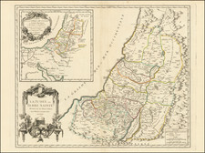
Interesting pair of two historical maps: one showing the residence of the Israelites in the Desert after the Exodus and one showing the divisions of the 12 Tribes.
The maps are beautifully detailed, showing many features throughout the Holy Land. The left map includes a map of the camp that the Israelites would make in the desert. The right map includes a plan of the city of Jerusalem.
This map was published by Matthew Carey for his edition of Lavoisine's Atlas in Philadelphia at the start of the 19th century.
Carey & Son refers to the period when Mathew Carey (1760-1839) ran his publishing business with his son, Henry Charles Carey (1793-1879). Mathew began the business in the 1790s and published several important atlases, including the earliest general atlas of the United States, the American Atlas. Henry entered the firm as a junior partner in 1817 and worked alongside his father until 1822, when his father retired and Henry bought out his father’s shares. They also brought in Isaac Lea (1792-1886) as a junior partner; Lea had recently married Henry’s sister. From then, the firm was known as Carey & Lea.
![[ Tribes of Zabulun Issachar, Manasseh ] Tribus Zabulon, Isachar, et, Dimidia Manasse altera, hoc est illae Terrae Sanctae regiones . . .](https://storage.googleapis.com/raremaps/img/small/95602.jpg)
![[Holy Land] Syria](https://storage.googleapis.com/raremaps/img/small/82757.jpg)