|
||

|

|
|

|
Stock# 87483
Description
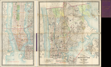
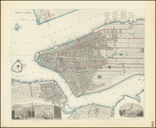
Large, folding, color-printed map of Manhattan, extending north to Central Park, published by D.A. Edsall & Co. in 1877.
A number of hotels (likely the advertisers) are shown in blue. Other important landmarks such as local churches and synagogues are listed.
Rarity
Haskell 1305, noting examples of this issue in NYPL and NYHS.
An 1879 edition was also issued (Haskell 1317). A later edition of 1880 with revisions was offered by High Ridge Books (Catalog 54).
Condition Description
Some stains, non-archival tape on verso, and loss in bottom left. Detached from cover
Reference
Haskell 1305