|
||

|

|
|

|
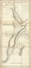
Detailed regional map of Egypt, centered on the Nile, and extending to the Red Sea, Palestine and the Desert west of the Nile.
Shows towns, islands, rivers, mountains, gulfs, bays, etc. Large inset showing the source of the Nile. Remarkable details along the River. Some of the roads and trading routes into the Desert are noted. Numerous annotations.
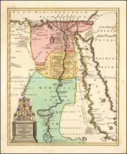
This map is from Tanner's New Universal Atlas, first issued in 1834. The Atlas would become the most popular American Atlas between 1834 and 1860, published annually, first by Tanner and later by Mitchell, Cowperthwait, and DeSilver. Tanner's career as a mapmaker began in the early 19th Century. He had a hand in publishing many of the most important American maps of the first half of the 19th Century. His business was carried on by his son Thomas and Henry Carey and flourished until the middle of the 19th Century.
![[Egypt] Appendix Tab III. Tabulae Afr:](https://storage.googleapis.com/raremaps/img/small/89158.jpg)
![Egypt called in the Country Missir by Monsr. D'Anville of the Royal Academy of Belles Lettres, & of that of Siciences [sic] of Petersburg Secretary to H.S.H. the Duke of Orleans. MDCCLXV.](https://storage.googleapis.com/raremaps/img/small/49130.jpg)