


|
||

|

|
|

|
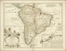
Stock# 87391
Description
Nice Pan Am-produced pictorial map of South America, showing the cultural and geographical diversity of the continent.
The map shows the indigenous peoples of South America, as well as some of the more famous cities and cultural sites. Various activities are shown throughout. The decorative elements extend into the sea.
This map was produced during the period of Pan Am hegemony. The map was drawn by Ayres Houghtelling and printed in 1943.
Condition Description
Nice, wide margins. Horizontal centerfold.

![[Soviet Russian Ecology Propaganda Poster] Основы Водного Законодательства Союза ССР](https://storage.googleapis.com/raremaps/img/small/68343.jpg)