


|
||

|

|
|

|
Fascinating infrastructure map of the area between western Iraq and northeastern Syria, mapping the progress of a major British project.
The map looks to relate to infrastructure planning by the British following the signing of the Franco-British Convention of December 23, 1920, Regarding the Mandates for Syria and Lebanon, Palestine, and Mesopotamia.
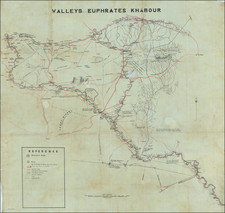
The map extends to Jarabulus and the future Lake Assad area in the northwest, Hit and the area immediately west of Ramadi and Therthar Lake in the southeast, and Tal Afar, to the west of Mosul in Iraq, tracking the course of the Euphrates River and its intersection with the Al Khabour River from the North.
The map includes a well-defined depiction of the modern border between Syria and Iraq north of the Euphrates to the Turkish border, with the exception of a small area east of Al Bukamal, near the current Syria-Iraq border crossing at Al Qa'im, Iraq.
The map is filled with assessments on the viability of transit by "M.T." We assume that "M.T." is "Motorized Transit".
There are references to the prospect of considerable delay resulting from "Landslides by Explosives" and the similar delays from the demolition of a "Stone bridge over deep wadi" north of Deirezzor on the Euphrates River.
In the south, a crossroads at "Resafe Resah Sergiopolis" is noted, giving 3 names for Resafa, Syria.
After the First World War, the Ottoman Empire disintegrated, and in 1918, the Arab armies under the leadership of Faysal entered Damascus and ended Ottoman rule in Syria. Syria’s liberation from foreign domination did not last long. On May 16, 1916, the French and the British signed the Sykes-Picot agreement, agreeing to share Greater Syria as follows: Syria and Lebanon would fall under the French Mandate, and Iraq, Palestine and Trans-Jordan would be under the British Mandate.
By 1919, the British in Mesopotamia had built rail lines from Basra to Baghdad (following the Euphrates Valley).
A large official map of the Euphrates river, capturing a section of the Iraqi - Syrian border region around the Khabor (Khabur), river. Rescued before it was due to go to the Ministry of Intelligence’s shredders, this is an amazing survival, evidencing a heightened period of tension between the English and Vichy France during WWII. Presumably for office use, we imagine that it was developed from a composite of sketch maps from the field, highlighting the need for reliable information to aid the advance.
This map was used for the British Syria-Lebanon campaign of June-July 1941. After successfully repelling the fascist-sympathizing Golden Square Iraq coup d’etat (led by the anti-British Prime Minister Rashid Ali), the British turned their attention to Vichy France who had offered their airfields in support of the group’s attacks against the British. The overarching aim of the advance was to reduce the capacity of Vichy airfields and limit the possibility of Axis attacks against Egypt and the Suez Canal, a key military asset for colonial Britain.
This map was intended for the bulk of the 10th Indian infantry division who advanced from Haditha (Iraq), up the Euphrates river. ‘The manoeuvre was intended to threaten the communication and supply lines of Vichy forces defending Beirut.’ (Raugh, 1993), and to harass the Vichy, stretching their forces.
Initially delayed by severe dust storms after setting out from Baghdad, the division was able to take Deir-ezzor on the 1st July. Part of the 21st Indian Brigade Group then continued to push up the river, harassing elements as far as Jerabulus on the Turkish border. On 12 July, Vichy French commanders sought an armistice, which was agreed with immediate effect. It was noted that the success of the operation was ‘largely due to the fine qualities and conduct of the Indian troops, resolutely led.’
Centered on the Syrian city of Deir-Ezzor, it reaches north to Djerabous, south as far as Hit and Mamura, west to Meskene (Maskanah, Syria), and east as far as Tel Afar (Iraq) along the Euphrates River. Whilst containing circled numbers of up to 55 as points of interest to soldiers, only number 16 (suspension bridge), and 7 (ferry), are directly referred to on this map. To aid with navigation, the map's reference lists tracks, motorable in dry weather, Metalled roads, Wadi beds or dried up tributaries, international boundaries, provincial boundaries, tracks and telegraph lines. Additional noted details of the terrain set out its intentions, including ‘High cliffs at different points, lateral movement difficult,’ or ‘Area of broken country movement of M.T restricted to tanks,’ clearly to aid the thinking of the command of the division.
All official material on the British Syria-Lebanon campaign is rare, especially large manuscript items such as this map. It helps illuminate an understudied part of the Middle East Theatre of WWII, and the important role played by Indian soldiers.*
![[Empire of Alexander The Great] Antiquor? Imperiorum Tabula in qua prae caeteris, Macendonia seu Alexandri Magni et Expeditiones exarantur . . .](https://storage.googleapis.com/raremaps/img/small/70608.jpg)

![[ Armenia, Azerbaijan, Georgia, Northern Iran, Northeastern Turkey ] The Countries Between The Caucus and Euphrates](https://storage.googleapis.com/raremaps/img/small/102209.jpg)