This item has been sold, but you can enter your email address to be notified if another example becomes available.


|
||

|

|
|

|
Stock# 87360
Description
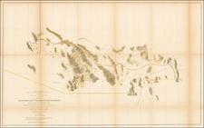
Original antique folding pamphlet showing the route of the Denver and Rio Grande Railroad, and connections, between western Colorado and San Francisco. The map shows the early 20th-century layout of railroads in the American Southwest and was produced by the railroad to advertise its fares.
The map also has a lengthy description of the railroad and its surroundings. The verso includes a number of images, including Pike's Peak, the Royal Gorge, and Temple Square, Salt Lake City.
Condition Description
Folding pamphlet, in fourteen sheets. Printed both sides.
![[ Southwest & Texas ] Le Nouveau Mexique, Avec La Partie Septentrionale De L'Ancien, ou De La Nouvelle Espagne](https://storage.googleapis.com/raremaps/img/small/99395.jpg)