


|
||

|

|
|

|
Rare 1849 First Edition!
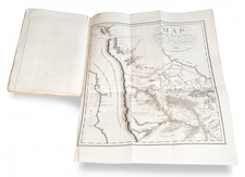
Important first edition of J.M. Atwood's classic decorative map of the Midwest, covering Ohio, Indiana, Michigan, Wisconsin, Illinois, Missouri, Iowa Territory, and Minnesota Territory.
This 1849 edition is noteworthy for its northwestern coverage, which shows the newly-reconfigured Iowa, Minnesota, and Wisconsin, following the creation of Minnesota Territory in the same year. One can see a line of counties running from Green Bay to the southwest corner of Iowa, marking the extent of thorough westward expansion at that point.
Minnesota Territory is shown in its earliest configuration, without its expanded western boundary (extending to the Missouri River) and first county configuration. The Minnesota cartography is clearly based on Nicollet but with some simplification and update (e.g., "St. Paul's" (sic) is added, as is "Kaposia P[ost] O[ffice]").
Decorative border, with inset views of Chicago, Detroit, Cincinnati, and St. Louis.
A nice example of one of the most decorative travelers' maps of the Midwest published before the Civil War.
While the 1850s states of the map are not particularly rare on the market, this 1849 first edition is. Because the map bears an 1848 copyright date, one will sometimes encounter 1848-dated examples; this appears to be erroneous.


![[Eastern Sheet -- Ohio] Post Road Map of the States of Ohio and Indiana with Adjacent Parts of Pennsylvania Michigan Illinois Kentucky and West Virginia Showing Post Offices With The Intermediate Distances and Mail Routes In Operation On the !st of February 1885 . . .](https://storage.googleapis.com/raremaps/img/small/44153.jpg)
