|
||

|

|
|

|
Stock# 87313
Description
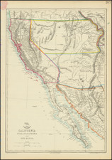
World War II-era air navigation chart for the Pacific between California and Hawaii, including the Hawaiian islands themselves.
The map was issued by the Hydrographic Office of the U.S. Navy for pilots to use flying over the Pacific during the Second World War. Thus the map is marked "Confidential".
The map shows California between Mendocino City and San Diego.
Condition Description
Folds, as issued. Some toning and wear.
![[ Orange County ] Geological Sketch Map S.E. Portion of Orange Co. California State Mining Bureau . . .](https://storage.googleapis.com/raremaps/img/small/76946.jpg)
![[WWII War Bonds] As](https://storage.googleapis.com/raremaps/img/small/63461.jpg)
![Johnson's North America [with Inset of Hawaii]](https://storage.googleapis.com/raremaps/img/small/88883.jpg)