This item has been sold, but you can enter your email address to be notified if another example becomes available.


|
||

|

|
|

|
Stock# 87308
Description
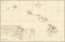
World War II-era air navigation chart for the Pacific southwest of Hawaii, including the islands themselves.
The map was issued by the Hydrographic Office of the U.S. Navy for pilots to use flying over the Pacific during the Second World War. Thus the map is marked "Restricted".
The map covers a host of islands and atolls and runs west to the Marshall Islands.
![Johnson's North America [with Inset of Hawaii]](https://storage.googleapis.com/raremaps/img/small/88883.jpg)