The item illustrated and described below is sold, but we
have another example in stock. To view the example which
is currently being offered for sale, click the
"View Details" button below.


|
||

|

|
|

|
Stock# 87246
Description
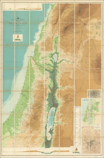
Large folding wall map of present-day Israel and vicinity, issued by John Bartholomew & Co. and the Edinburgh Geographical Institute
Elevation is shown by color gradation. The greatest known depth of the "Dead Sea or Salt Sea" is shown as 1308 feet or "(2600 ft. below level of Mediterranean)".
The map has seven insets: "Section across Galilee and the Jordan Valley"; "Reference to coloring lines showing height of land & depth of sea"; "Section across Judea and the Dead Sea"; "Plan of Jerusalem from the Ordnance Survey"; "Vegetation Map of Modern Palestine"; "London on Same Scale as Large Map - 4 Miles to an Inch".
Scarce. This is the first time we have offered the map for sale.
Condition Description
Folding map. Backed on original linen. Wear and some separation (including of the linen) at fold intersections. Original gilt-lettered blue cloth folder, with tape and stickers partially removed or obscured. Some pencil inscription.
![De Schepping der Wereldt Volgens de Beschryving van Mozes. 1 Plaat [in set with] De Schepping der Wereldt Volgens de Beschryving van Mozes. 2. Plaat](https://storage.googleapis.com/raremaps/img/small/102641.jpg)