


|
||

|

|
|

|
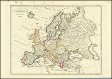
Attractive original antique map of Europe, published by Samuel Augustus Mitchell in Philadelphia in 1846.
The map shows Europe before the Revolutions of '48 and, notably, before the unification of Italy and the unification of Germany. To that end, a reference list in the upper-left corner numbers member states of the Germanic Confederation, as well as the constituent states of Italy.
For over fifty years, Samuel Augustus Mitchell, his son, and his successors some of the most prominent publishers of maps and atlases in the United States. Samuel Augustus Mitchell Sr. was born in Bristol, Connecticut on March 20, 1792. His father had emigrated from Scotland in 1773. While little is known about his early schooling, it is known that Mitchell found the quality of early geography text books to be lacking, and determined that he would write and publish better works. This decision led him to relocate to Philadelphia in 1829 or 1830, which was then the center of commercial publishing in America.
Mitchell’s first cartographic work was the re-issue of Anthony Finley’s New American Atlas in 1831, a work first issued by Finley in 1826, in response to Henry Schenk Tanner’s monumental work of the same title, issued in serial format from 1818 to 1822 and as a complete work from 1823 onward. While the map content in Mitchell’s edition of the New American Atlas is the same as Finley’s edition, each map has been significantly improved and revised, primarily with the addition of new towns and roads. This is especially true in the south and west. Finley had originally collaborated with D.H. Vance and J.H. Young in the preparation of the maps, although Vance’s name is removed from the Mitchell edition. Mitchell continued to work with Young, an association which would continue for several decades.
Following publication of the New American Atlas, Mitchell began issuing the individual maps in pocket map format. From 1834, Mitchell began offering reduced sized Tourist Pocket Maps of a number of states in the United States. J.H. Young and D. Haines are listed as the engravers on these maps. In 1832, Mitchell offered the first edition of his Travellers Guide Through the United States, A Map of the Roads, Distances, Steam Boat & Canal Routes &c. By J.H. Young . . ., which would become one of his most popular and enduring works. The map of the United States was done by steel engraving, one of the earliest uses of the technique in map publishing in America. In the same year, the first edition of Mitchell’s Map of the United States, by J.H. Young was issued, bearing the copyright date of October 10, 1831. This map would be revised and issued until 1844. Young also compiled A New Map of the United States in 1833. These two wall maps would come to dominate the market and their success led to several later US wall maps issued by Mitchell. This second map was also issued under the title of Mitchell’s Reference and Distance Map of the United States, which was printed until 1851.
Mitchell was neither a cartographer nor an engraver. His primary function was as the editor and business manager of his publishing company, with Young working as the primary maker of maps. Beginning in 1839, Mitchell also began publication of his school atlas. This work and variant editions for older and younger students, was issued by Mitchell and his successors from 1839 to 1886. In 1845, Mitchell acquired the rights to Henry Schenk Tanner’s New Universal Atlas from Carey & Hart, which had previously acquired the copyright from Tanner and had published editions of 1843 and 1844. Mitchell changed many of the maps and issued two editions of the atlas in 1846. He changed the copperplates to lithography, utilizing Peter S. Duval in Philadelphia to produce the stones. Mitchell re-issued the atlas at least annually until 1850, when he sold the rights to the work to Thomas, Cowperthwait & Company.
In 1860, Mitchell’s son, Samuel Augustus Mitchell Jr. began issuing Mitchell’s New General Atlas. While his father had continued to issue wall maps and other works, this appears to be his son’s first entry into the trade. The New General Atlas was issued by SA Mitchell Jr. until 1887. From 1880 to 1887, Bradley & Company also published the atlas. Various other minor publishers, including A.R. Keller, produced editions as late as 1894. The elder Mitchell died in 1868. Samuel Jr. continued the business until the 1890s. At its height, the Mitchell Company employed 250 people and sold 400,000 publications annually.
![[ Ancient World ] Christianographie](https://storage.googleapis.com/raremaps/img/small/80305.jpg)
![[ Europe according to Ptolemy ] Europa nach Ptolemaeos](https://storage.googleapis.com/raremaps/img/small/97254.jpg)