|
||

|

|
|

|
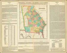
Rare separately published pocket map of Georgia, published by Georgia's most important mapmaker of the period.
Bonner's map is a comprehensive mapping of Georgia, published by William Bonner, a civil engineer resident in Georgia's then-state capital Milledgeville. While the map suggests that it was printed for George White's exceedingly rare 1855 Historical Collections of Georgia, this example was separately published, with a deluxe decorative border.
The present map was issued one year after the Georgia-Florida boundary dispute was resolved in 1854 by the U.S. Supreme Court, which ruled in favor of Florida, adopting the northernmost, or "McNeil's Line," rejecting the Crawford and Cooper Line of 1831 and a second more northerly line which had been called "the True Line by J.R. Butts, Surveyor on the part of Georgia 1854".
In 1847, William G. Bonner published a wall map of Georgia, the largest separately published map of Georgia prior to the Civil War. Prior to 1847, the best large format map of Georgia was the Early-Sturges map of 1818. As Georgia grew in population and became increasingly more settled, the Georgia Legislature addressed necessity of an improved large format comprehensive map, which resulted in the retention of William G. Bonner to create such a map. Bonner, a civil engineer, constructed his map by compiling existing material available in Milledgeville and adding information received from county magistrates. As noted in several excerpts from the Macon Weekly Telegraph,
We have witnessed the progression of this work, since its commencement, almost daily. It has been executed at the Capitol, where reference has been easy to the statutes regulating boundary lines, and to all the surveys ever ordered by the State authorities (November 24, 1846).
It appears that Mr. B[onner]. is exceedingly desirous of having a particularly correct outline of each county, with all the public places therein, or whatever may be of local or general interest, noted with care. For this purpose he has furnished a number of counties in the State, through the Executive, with a rough map upon which the Inferior Court were requested to [sic] have dotted and marked the particulars above referred to, and return the same (June 9, 1846).
The resulting map was the largest scale map of Georgia produced to date, emphasizing the state's natural geography and topography. The Georgia-Florida boundary, which was still then in dispute, was indicated by three alternative borders. The dispute was resolved in 1854 by the U.S. Supreme Court, which ruled in favor of Florida, adopting the northernmost, or "McNeil's Line."
Bonner's map was apparently well received, receiving considerable praise in local newspapers, as well as the backing of the General Assembly, which subscribed to 130 copies of the first edition for distribution to each county and the other states.
The Bonner wall map was periodically updated over the next decade, with OCLC editions of 1847, 1851, 1854, and 1857, while Phillips' Maps of America, adds an 1859 edition at the Library of Congress A later revised map of Georgia would be published on a similar scale by A.G. Butts in 1870, 1871, 1882 and 1889.
States of the Map and Rarity
Bonner's pocket map of Georgia was issued in 1848, '49, '51, '53, '54, and '55, all of which are very rare on the market.
We note the following examples offered for sale at auction:
- 1848 offered for sale by Midland in 1955
- 1849 offered at auction by Swann Galleries in 1849
- 1851 offered for sale by High Ridge Books in 2001 ($4000)
- This 1855 example, purchased at auction in 2022.
![Neueste Karte von Georgia mit seinen Strassen, Eisenbahnen und Entfernungen 1845. [Latest Map of Georgia with its Roads, Railways, and Distances 1845.]](https://storage.googleapis.com/raremaps/img/small/94441.jpg)

![[ Carolinas & Georgia ] Carte De La Caroline Et Georgie . . .](https://storage.googleapis.com/raremaps/img/small/99744.jpg)