


|
||

|

|
|

|
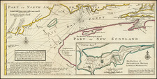
The Finest 18th-Century Chart of Chignecto Bay and Beauséjour, from the Capstone British Mapping of North America.
Important map of the land bridge between Nova Scotia and the rest of Canada, published by J.F.W Des Barres for his Atlantic Neptune.
The map shows the strip of land between the Bay of Fundy and the Baie Verte at the border between present-day Nova Scotia and New Brunswick, which was of immense strategic importance at the time. Detail on the map is exemplary of early colonial surveys, with topography, rivers, place names, and cultivated areas shown. Fort Cumberland (having been renamed from Fort Beauséjour), farms, towns, and more are all shown. Depth soundings are provided in the Bay of Fundy, with reefs, capes, and much more all shown.
The Isthmus of Chignecto had been the subject of contention since the 17th century. Since Nova Scotia was a British colony and the region to the west was historically French, this narrow strip of land was extensively fought over. The British led raids on French settlements in the area during King William's War and Queen Anne's War, and at least three skirmishes happened there between 1749 and 1751 during Father Le Loutre's War. The British finally captured the region from the French in 1755 during the Battle of Fort Beauséjour.
The loss of the French in the Battle of Beausejour is often cited as a major reason for the forced expulsion of the local Acadians. Following the humiliating defeat of several British forces that year, the forced deportation of the Acadians in occupied territories was undertaken to deprive the French of fighting forces and to promote a perceived victory.
State
This is the final, most complete state of six recorded by the National Maritime Museum, with the imprint date advanced to 1780 and other changes made.
J.F.W. Des Barres and The Atlantic Neptune
Des Barres's chart of the Isthmus of Nova Scotia was issued both separately and in The Atlantic Neptune, an atlas of charts and views of North American waters used by British navigators throughout the Revolution. The charts were of extraordinarily high quality and remained the standard for decades, becoming the standard reference work for cartographic information used by American and European engravers and publishers for decades thereafter. On a broad scale basis, it was not until the United States Coast Survey commenced issuing maps in the middle of the 19th century that a more detailed and systematic charting of the Northeast was made under the auspices of a single project.
The charts of the Atlantic Neptune which focus on New England were based on original surveys made in the 1760s, mainly under the direction of Samuel Holland, a Dutch-born surveyor and engineer who entered British service during the French and Indian War. After this war, Holland had proposed "an accurate and just Survey… upon… a general scale and uniform plan" of North America east of the Mississippi. This was to be a "geodetic" survey following the most advanced methods then in use in Europe, but applied for the first time in North America: the locations of control points would be established by rigorous astronomical observation, intermediate areas pinpointed by triangulation, and details sketched in from direct observation.
Holland's proposal was approved by the British Colonial offices, and in 1764 Holland was named Surveyor General of both the Province of Quebec and the Northern District of North America, from the Potomac to the border with Canada. After several years work in the Canadian Maritimes, from 1770-1774, he focused on the New England coast, making his headquarters in Portsmouth. From Portsmouth, Holland sent out survey teams headed by his deputies Charles Blaskowitz, James Grant, George Sproule, Thomas Wheeler and Thomas Wright, utilizing the sloop HMS Canceaux.
Holland's finished surveys were sent to England, where Des Barres oversaw the work necessary for their engraving and publication. The demand for charts was high in those unsettled times, and Des Barres' operation soon occupied two townhouses and 20 assistants in compiling, drafting and correcting the charts. While The Atlantic Neptune was usually made up to order and had no standard collation, it ultimately extended to five sections: Nova Scotia, New England, the River and Gulf of St. Lawrence (based on the work of James Cook), the coast south of New York, and American coastal views.
Des Barres's complete work is all but unobtainable on the market. A copy sold in March of 2022 at the Kislak Jay Kislak sale for over $1,000,000.
Joseph Frederick Wallet Des Barres (1721-1824) was born in either Paris or Basel, Switzerland, to a Hugueont family. He studied under the great mathematician Daniel Bernoulli at the University of Basel before immigrating to Britain, where he trained at the Royal Military College, Woolwich.
Upon the outbreak of hostilities with France in 1756, he joined the British Royal American Regiment as a military engineer. He came to the attention of General James Wolfe, who was impressed with his charting ability. During this period, he also worked with the legendary future explorer, James Cook, on a monumental chart of the St. Lawrence River.
Des Barres is best known for the Atlantic Neptune, was a remarkable, multi-volume set of sea charts and coastal views prepared from recent surveys, some of which were overseen by Des Barres in Nova Scotia after the Seven Years’ War. The maps, charts, and views were prepared under the supervision of Des Barres and employed as many as twenty engravers and assistants. They were produced over the course of a decade, from 1774 to 1784, in time to be used by the Royal Navy in the American Revolution.
After the Revolution, Loyalists were resettled throughout Canada. As part of this process, a new colony was created by separating Cape Breton from Nova Scotia. Des Barres, who already owned extensive lands in the Maritimes, served as lieutenant governor of Cape Breton Island from 1784 to 1787. He later served as governor of Prince Edward Island from 1804-1812.
Des Barres lived an exceptionally long life, even by today's standards, finally dying at age 102. Des Barres' funeral was held at St. George's Round Church in 1824 and he is buried in Halifax.
![[ Cape Cod to Acadia ] Pas-Kaart Vande Zee Kusten inde boght van Niew Engeland Tusschen de Staaten Hoek en C.de Sable . . .](https://storage.googleapis.com/raremaps/img/small/94453.jpg)
![[ St. Lawerence River / Lake Champlain ] Carte Du Cours Du Fleuve De St. Laurent Depuis son Embouchere jusqu'au dessus de Quebec . . .](https://storage.googleapis.com/raremaps/img/small/101652.jpg)
