


|
||

|

|
|

|
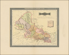
The Final Major Spanish Expedition To Chart The Coast of Yucatan and Environs.
Clearly Showing the Phantom Isla Bermeja.
Rare 1821 edition of this important Spanish sea chart of the Gulf Coast of Mexico and the Yucatan.
Fantastic large-scale printed chart of the Coast of Mexico based upon actual soundings and explorations, which would later be re-issued in 1825 in the rare 14 chart Atlas y Portolano de la America Septentrional, published in Mexico in 1825, to commemorate Mexican independence from Spain.
Isla Bermeja
This chart shows many soundings and other hydrographic details off the north coast of the Yucatan Peninsula. Importantly, the chart shows "Ia. Bermeja" the infamous disappearing island of the Gulf of Mexico, which showed up on numerous charts until being declared missing by a 1997 survey. This was subsequently confirmed by additional surveys of the area.
The issue of the disappearing island came to the fore when, in 2008 and 2009, the United States and Mexico negotiated offshore drilling rights in the Gulf of Mexico. Had the island still existed, Mexico would have had a larger claim to undersea drilling rights in the Gulf.
Bermeja was first discovered in 1539 and featured on many maps after that time. This map is noteworthy because of the detailed and definite bathymetric mapping of area immediately around the island, which lends credence to the claim that the island actually did exist at that time. Indeed, there is a note on the map that it is updated according to the situation of the Isla de Arenas (Cayos Arcas) just to the south of Bermeja.
Rarity
First issued in 1808, the map would be revised in 1814, 1821, and 1846 and also issued as noted above in 1825 in Mexico City.
We locate only a single example of the map in the National Library of Spain.
The Dirección de Hidrografía, or the Directorate of Hydrographic Works, was established in 1797. Its roots were in the Casa de Contratación, founded in 1503 in Sevilla, which housed all the charts of the Spanish Empire and oversaw the creation and maintenance of the padrón real, the official master chart. The Casa, now in Cadiz, was shuttered in 1790, but Spain still needed a hydrographic body. In response, the Dirección was created in 1797. One of its first projects was the publication of charts from the Malaspina Expedition (1789-1794). The Dirección oversaw not only publication, but also surveying. The Dirección was abolished in the early twentieth century, when their work was distributed to other organizations.
![[Austins Colony] Mexico & Guatemala](https://storage.googleapis.com/raremaps/img/small/94054.jpg)


![(Mexican Antiquities - Photography) [Western Facade of the Fourth Palace, Mitla, Oaxaca; Quatrieme Palais, à Mitla, façade occidentale] [Plate 15 from:] Cités et Ruines Américaines](https://storage.googleapis.com/raremaps/img/small/93940.jpg)