This item has been sold, but you can enter your email address to be notified if another example becomes available.


|
||

|

|
|

|
Stock# 8709
Description
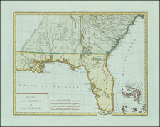
Highly detailed map of East and West Florida. One of the earliest maps to focus on what would become the State of Florida and one of the best examples of the Florida as an Archipelago genre, showing Southern Florida as a group of about 50 massive islands and a number of wide navigable water routes from the Gulf to the Atlantic . The map is rich with place names and other early details. One of the most detailed maps of Florida for the period and one of the most curious. A bit of soiling in the right margin, else a nice example.

![(Southeast United States) Carte de la partie sud, des Etats Unis de L' amerique septentrionale [Map of the southern part of the United States of North America]](https://storage.googleapis.com/raremaps/img/small/98738.jpg)