This item has been sold, but you can enter your email address to be notified if another example becomes available.


|
||

|

|
|

|
Stock# 87070
Description
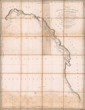
Impressive sectioned wall map of California published by the Heald-Menerey Company in 1927.
The map is presented in the characteristic Heald style, cut into horizontal strips that fold into a bound volume. The map shows highways and roads, trails, railroads, streams and rivers, lakes, springs, aqueducts, lighthouses, county lines, national forests and parks, and township and range lines. Includes insets of San Francisco and Los Angeles.
Southern California is offset so that the image can better fit in its condensed format. Insets of San Francisco and Los Angeles sit in the Pacific Ocean.
The map includes many smaller community names that have since been subsumed by larger neighbors and forgotten.
Rarity
The map is quite scarce. Not in Rumsey.
Condition Description
Map dissected in 8 horizontal strips, joined at left edge, folding into the original paper biding.
![(Bird's-Eye View of California) San Francisco Invites You [cover title]](https://storage.googleapis.com/raremaps/img/small/92552.jpg)
![California Water and Mining Co. [with:] Map of El Dorado County, Cal. Showing the Georgetown Divide and Portions of the Placerville and Forrest Hill Divide with the Ditches, Mines and Other Properties of the California Water Co. Situated Between The South Fork of Middle Fork and the South Fork of the American River 1880](https://storage.googleapis.com/raremaps/img/small/91927.jpg)