|
||

|

|
|

|
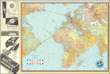
Important Multi-Lingual WWII Propaganda Map -- The French Edition of Blake's "The Battle of the Atlantic"
Provocative World War II propaganda poster, highlighting the strength of the allied forces during the Battle of the Atlantic, drawn by noted Scottish artist Frederick Donald Blake.
Issued in a number of languages, including English, French, Portuguese and Arabic, the map shows Britain at the center of a massive air and sea campaign to eradicate the threat of German U-Boats, which had menaced allied shipping throughout the initial years of the war. Hunting in so-called wolfpacks or Rudeltaktik, Germany's undersea naval force had waged an effective campaign to cut off naval forces from the mainland of Europe and isolate Britain.
The image shows a massive convergence of seacraft from the United States, Canada, the Mediterranean and "Orient", and Russia, supported by dozens of aircraft leaving Great Britain, in an all out effort to secure passage through the Atlantic and reinforce the Allied forces on the continent. Along the French Coastline and the German Coast in the North Sea, images of catastrophic German losses provided hope and encouragement to the view of the strength of the allied forces and growing success of the war effort, including smashing German reinforcements sent by rail through occupied France.
We date the map based upon the English sub-title "1944 Marks A Triumph in the Battle of the Atlantic". This is one of several such propaganda maps by Blake, which also included Britain Spearhead of the Attack,

![[ France / Roman Gaul ] Galliae Veteris Typus](https://storage.googleapis.com/raremaps/img/small/98777.jpg)