


|
||

|

|
|

|
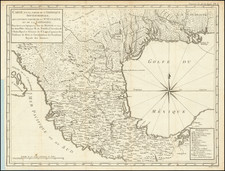
"[T]he best representation of Texas as it was just before annexation." - Streeter, Texas, 1627
Rare. No Examples Traced in Texas.
The First Map of Texas to Show Dallas.
The Basis for the Roemer Map of Texas.
A handsome example of one of the Holy Grails of Texas map collecting, called by Streeter one of the six most important maps for Texas collectors.
This is James T. D. Wilson's vanishingly rare map of 1845, which can today be located in only three institutions, none of them in Texas. The map provides the best contemporary representation of the Republic of Texas just before its annexation into the United States. Especially on the Texan frontier, Wilson's effort far surpasses the other maps of the Republic available at the time; first and foremost among its improvements is the inclusion of Dallas, with a detailed treatment of the region around the new town, representing the first appearance of that city on a map.
It is surmised that Wilson largely compiled the map from sources in the General Land Office. Wilson includes the frontier forts established to protect the core of the Republic from Comanche raids (e.g., Fort Houston and Parkers Fort). He also includes a level of detail of grant information (with many notes along the lines of: "4th Grant in 1843 to the Texas Emigration & Land Company"), landform and land cover (e.g., "Mitchells Bluff", "Cedar Spring", "Pilot Grove"), roads, and smaller settlements, which put competing maps to shame.
Wilson's treatment of Texas west of the frontier (100th Meridian) is far sparser, as one would expect. However, he still makes an effort to include notes about Indian villages and some references to land cover.
Use by Ferdinand Roemer
Wilson's map formed the basis for Ferdinand Roemer's 1849 mapping of Texas - the first geological map of the state. Roemer had traveled to the U.S. in 1845 and remained there until 1847, an optimal time to have encountered Wilson's map, as well as other potential base maps. Roemer credits Wilson in the title of his map ('...geographischen Karte v. Wilson...").
Roemer selectively reduced the information from Wilson, especially for the counties shown. In other instances, he added to the map - for instance, Friedrichsburg, west of Austin, is added in Roemer's map, as is an allusion to an 1847 route from that town.
Commentary in the Literature
Martin & Martin 35:
James Wilson (New Handbook VI:1006) was only twenty-five when he made his map of Texas in 1845, but he was already a man of wide experience. Born in 1820 in St. Louis... by the time he had reached the age of fifteen he had lived in Missouri, Mississippi, Virginia, Kentucky, and Ohio, and held an assortment of jobs. He journeyed to Texas in 1835, fought in the Texas Revolution, and eventually joined his father, by then a land speculator and sometime politician in the real estate business in Houston. It was probably in connection with this business that Wilson made his map.
The 'Authorities' on which Wilson based the map appear to be predominantly the General Land Office.... The map was extremely detailed and accurate to the 100th meridian. The coast and rivers of the region appeared much as they should, and other natural features such as the Cross Timbers in the north and the mesquite range in the south were graphically displayed. Enchanted Rock, though unnamed, appeared as a landmark. The political features include all thirty-six counties then organized, along with their towns and settlements. He depicted several colonization ventures along with the grants to the Texas Emigration and Land Company in North Texas, and to C. Mercer. The recently established German colony in central Texas is marked as a 'Dutch settlement' near the site of New Braunfels. A network of roads and trails connected the settlements throughout the area and included 'Trammels Trail' in East Texas and the 'Route of the Santa Fe Expedition' in the central region.
The detailed depiction of the eastern half of the Republic was in stark contrast to the dearth of information west of the 100th meridian, which gave a clear indication why many maps of the period...failed to include that part.... Wilson lived until 1902, and he twice served as the mayor of Houston, but he never made another map. His single effort is now a great rarity, surviving in only two copies, and it is perhaps the best depiction of Texas on the eve of annexation. It clearly illustrated the progress of settlement and the nearly total lack of information in the west, a region that was to remain the domain of the Comanche and the coyote for another thirty years.
Streeter 1627:
This excellent large scale map gives the best representation of Texas as it was just before annexation. It extends from slightly below the 26th parallel and the mouth of the Rio Grande north to the 35th parallel, and so includes only a part of the Texas Panhandle. The east-west coverage is from about the meridian of Natchitoches to almost the 107th meridian, or about a degree west of El Paso. There are legends for "Route of the Santa Fe Expedition," "Old route from Santa Fe to San Antonio," and "Route of the Texian Prisoners from Santa Fe to the City of Mexico." The five grants to C.F. Mercer are shown and there is a legend for "Fisher & Miller's Colony," bounded on the north by the Colorado River above Austin. Thirty-six counties are shown, as on the map in the 1845 edition of the Hunt and Kandel Guide, entry No. 1348B. An almost exact copy of the eastern portion, to the 101st meridian of this Wilson map, entitled "Map of Texas," and with a legend above the neat line, "Standidge & Co, Litho, London," is at the Library of Congress. It is undated and well may have been published or included in a book after 1845.; Locations: DLC. TWS.
Rarity
We note examples at the Library of Congress (cited by Streeter, though not traced online), Yale (Streeter collection), and Newberry Library (Graff collection).
In 1998 Dorothy Sloan sold another example of the map. "This is the only copy that we can recall having been offered on the open market." Since then, we find no copies having been offered for sale.
Conclusion
Wilson's exceptional map of Texas is the visual embodiment of the accomplishments of the Republic period. Whereas Stephen F. Austin's Texas project began with land grants carved in the wilderness with scant paths connecting a handful of small settlements, only a decade later it had grown into a full-fledged nation with large towns, forts, ranches, and counties. This map, more than any other, summarizes the triumph of that era.

![[ Gulf Coast & West Coast of Florida ] De Cust van Westindien Van La Desconoscida, tot C. Escondido. . .](https://storage.googleapis.com/raremaps/img/small/65741.jpg)