|
||

|

|
|

|
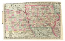
The Most Detailed of the Early Map of Iowa.
A handsome example of the best early mapping of Iowa, published by J.H. Colton in New York in 1840, based on information compiled by Jesse Williams. The map appears in Williams's description of Iowa, one of the first texts on the new U.S. territory.
U.S. governmental surveys of Iowa began just as the territory was split from Wisconsin in 1838. The results of the surveys flowed through the Surveyor General's Office in Cincinnati. Thus, L. Judson produced the first separate map of Iowa Territory (per Karrow) in 1838 in Cincinnati. Demand for materials about new territories often shot up right after the territory was created, and J.H. Colton produced his first separate map of Iowa in 1839.
Perhaps Jesse Williams saw the Colton and Judson maps as inferior to what he could produce; as a clerk in the Surveyor General's Office in Cincinnati, Williams had access to the best versions of the surveys done in Iowa. Because of his inside track, he could compile a map with more detail than before, especially in rendering landform and topographical data. On Williams's map, the bluffs of the Mississippi are carefully shown (lacking from the Judson), prairies and wetlands are rendered pictorially, and small groups of hills are indicated with hachuring. Williams's key lists the following symbols: Towns, Roads & Trails, Hills, Ledges of Lime and other Rock, Coal Banks, Bluffs, Rapids, Lead Ore, Marshes, and Prairies.
The lines of the Black Hawk Cessions of 1832 and 1837 are indicated by dotted lines.
Williams included two inset maps of rapids on the Mississippi. One titled "Map of Rock Island Rapids Of the Mississippi River." The other "Map of Des Moines Rapids of the Mississippi River."
A bald eagle in the upper-left corner faces west, indicating the inclination for American expansion beyond the Mississippi.
Jesse Williams
According to Iowa historian Jack Johnson;
During the time he was Territorial Auditor, and because of his experience with land affairs, Jesse Williams compiled A Description of the United States Lands in Iowa. The one-hundred-eighty- page book, published by J. H. Colton in 1840, was bound in blue paper and contained a detailed map signed by Jesse William, “late a Clerk in the Surveyor General’s Office, Cincinnati”. According to the author, the volume included “a minute description of every section and quarter section, quality of soil, groves of timber, prairies, ledges of rock, coal banks, iron and lead ores, water-falls, mill-seats, etc."
The skill in compiling the information from the records of the United States survey testifies for Williams’s training. There was truth in the statement by the author that the “book and map will furnish the possessor with more information concerning Iowa than can be obtained from any other source."
The First Maps of Iowa
The following is an overview of the earliest separately-published maps of Iowa, from 1838 to 1841:
1838. Judson, L. Iowa. A sectional Map of the Black Hawk Purchase with a part of Illinois and Wisconsin. Engd. by Doolittle & Munson Cini.
1839. Colton, J.H. Map of the Surveyed part of Iowa New York, Published by J.H. Colton. 1839.
1840. Williams, Jesse. Map Of the Surveyed part of Iowa; Exhibiting the Sections, Townships & Ranges Compiled from the United States Surveys By Jesse Williams, Late a Clerk in the Surveyor General's Office, Cincinnati
1840. Colton, J.H. Map of the Surveyed part of Iowa New York, Published by J.H. Colton. 1840.
1841. Newall, John B. Newhall's Map of Iowa Compiled from the United States Surveys... J.H. Colton, New-York. 1841.
This example varies slightly in that the accompanying text is a physical description of the land and its organization rather than a guidebook through the Iowa Territory, but it remains a scarce representation of early settlement in the Iowa Territory.
Rarity
Only one example is recorded at auction since the 1967 Streeter sale, sold in 2008. At the Streeter sale (Lot 1880), the book made $250.
Howes (W459), rates the book "b".
OCLC indicates the Williams book is well-represented institutionally. Some of the entries appear to be "Internet Resource" locations mixed with actual physical copies.
G. W. & C. B. Colton was a prominent family firm of mapmakers who were leaders in the American map trade in the nineteenth century. Its founder, Joseph Hutchins Colton (1800-1893), was a Massachusetts native. Colton did not start in the map trade; rather, he worked in a general store from 1816 to 1829 and then as a night clerk at the United States Post Office in Hartford, Connecticut. By 1830, he was in New York City, where he set up his publishing business a year later.
The first printed item with his imprint is dated 1833, a reprint of S. Stiles & Company’s edition of David Burr’s map of the state of New York. He also printed John Disturnell’s map of New York City in 1833. Colton’s next cartographic venture was in 1835, when he acquired the rights to John Farmer’s seminal maps of Michigan and Wisconsin. Another early and important Colton work is his Topographical Map of the City and County of New York and the Adjacent Country (1836). In 1839, Colton began issuing the Western Tourist and Emigrant’s Guide, which was originally issued by J. Calvin Smith.
During this first decade, Colton did not have a resident map engraver; he relied upon copyrights purchased from other map makers, most often S. Stiles & Company, and later Stiles, Sherman & Smith. Smith was a charter member of the American Geographical and Statistical Society, as was John Disturnell. This connection would bear fruit for Colton during the early period in his career, helping him to acquire the rights to several important maps. By 1850, the Colton firm was one of the primary publishers of guidebooks and immigrant and railroad maps, known for the high-quality steel plate engravings with decorative borders and hand watercolors.
In 1846, Colton published Colton’s Map of the United States of America, British Possessions . . . his first venture into the wall map business. This work would be issued until 1884 and was the first of several successful wall maps issued by the firm, including collaborative works with D.G. Johnson. From the 1840s to 1855, the firm focused on the production of railroad maps. Later, it published a number of Civil War maps.
In 1855, Colton finally issued his first atlas, Colton’s Atlas of the World, issued in two volumes in 1855 and 1856. In 1857 the work was reduced to a single volume under the title of Colton’s General Atlas, which was published in largely the same format until 1888. It is in this work that George Woolworth (G. W.) Colton’s name appears for the first time.
Born in 1827 and lacking formal training as a mapmaker, G. W. joined his father’s business and would later help it to thrive. His brother Charles B. (C. B.) Colton would also join the firm. Beginning in 1859, the General Atlas gives credit to Johnson & Browning, a credit which disappears after 1860, when Johnson & Browning launched their own atlas venture, Johnson’s New Illustrated (Steel Plate) Family Atlas, which bears Colton’s name as the publisher in the 1860 and 1861 editions.
J.H. Colton also published a number of smaller atlases and school geographies, including his Atlas of America (1854-56), his Illustrated Cabinet Atlas (1859), Colton’s Condensed Cabinet Atlas of Descriptive Geography (1864) and Colton’s Quarto Atlas of the World (1865). From 1850 to the early 1890s, the firm also published several school atlases and pocket maps. The firm continued until the late 1890s, when it merged with a competitor and then ceased to trade under the name Colton.

![North America Sheet IX Parts of Missouri, Illinois and Indiana [and the Sioux District]](https://storage.googleapis.com/raremaps/img/small/84193.jpg)