


|
||

|

|
|

|
The Vast Pacific Ocean
Striking example of Reiner and Joshua Ottens' chart of the Pacific Ocean, an updated state of Frederick De Wit’s chart of 1675.
The map prominently shows California as an island (see below), a geographic myth that was losing purchase by the time the Ottens published the map.
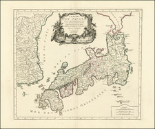
Across the sea, the depiction of Japan strikes the modern eye as odd. It is shown largely horizontally, a typical representation at the time. North of the main islands is a large protrusion that extends into the border of the map, Terre de Iesso; to the east is another set of islands called Terre de la Compagnie. These North Pacific chimeras (see below) often appeared on maps of the seventeenth and eighteenth centuries. In this state, Tartary is included and the shapes of Iesso and Compagnies Land have been altered.
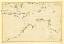
In the southwest is a curious, disjointed portrayal of New Guinea and Australia. First, we see a nearly round New Britain. This island was named by William Dampier, a buccaneer naturalist who visited on one of his three circumnavigations. He arrived in 1700, showing how this state was updated as compared to earlier examples.
New Guinea is shown as a long thrust which almost connects to Carpentaria, which is part of Australia. At the time of publication, only the Spanish knew of the strait between the two, as it had been discovered on a Spanish voyage in 1605. However, the navigator, Torres’, information was sequestered in Spanish archives until the 1760s, leading to many maps that suggest a close relationship between New Guinea and Australia.
The toponyms in Australia come from early Dutch encounters with that coast, particularly the voyage of the Duyfken in 1605-06. Under the command of Willem Janszoon, the Duyfken explored the eastern shore of the Gulf of Carpentaria, just below the Cape York Peninsula, a venture which was famously the first recorded European contact with Australia.
Farther south are the partial shores of Van Diemen’s Land and New Zealand. These come from the first voyage of Abel Tasman. By the 1640s, the officials of the VOC were eager to know the extent of the south lands and if they included any useful resources or willing trading partners. They appointed Abel Tasman to pursue these questions. Tasman's 1642-43 voyage was the first to circumnavigate the whole of the Australasia region, thus proving it was a separate entity unconnected from a mythical, and massive, southern continent. He surveyed the south coast of Tasmania, which he called Van Diemens Land after the VOC governor of Batavia, and the western coast of New Zealand, as well as the Tonga and Fiji Archipelagos. While important for geography, his voyage was nevertheless a disappointment to the VOC, as it netted no new commercial opportunities.
His second voyage proved even less successful. He was supposed to find a passage south of New Guinea to the east coast of Australia, but he missed the strait and instead thought it a bay. He did, however, more fully chart Australia’s northern coastline, which had only been sporadically encountered to that point.
The final innovation of this chart is the inclusion of the Solomon Islands and the strange T Land van den H. Geest. The Solomons had been known since the 1670s, following the first voyage of Alvaro de Mendaña (1565-7). However, their exact location remained a matter of debate.
The chart is finished with a series of ships in full sail. There is also a notable cartouche with Neptune and a companion ensconced in a shall chariot and pulled by mighty horses and guardians.
States of the chart
The chart, based on a similar Goos chart of 1666, was first published in de Wit’s Orbis Maritimus ofte Zee Atlas in 1675. It was updated to include Compagnies Land in a second state before 1690.
Renard re-issued this state in ca. 1715.
This is the final state, which includes New Britain, Tartary, and more central Pacific islands, and was issued ca. 1745.
North Pacific chimeras: Yesso, De Gama, and Compagnie Land
The etymology of the idiom Yesso (Eso, Yeco, Jesso, Yedso) is most likely the Japanese Ezo-chi; a term used for the lands north of the island of Honshu. During the Edō period (1600-1886), it came to represent the ‘foreigners’ on the Kuril and Sakhalin islands. As European traders came into contact with the Japanese in the seventeenth century, the term was transferred onto European maps, where it was often associated with the island of Hokkaido. It varies on maps from a small island to a near-continent sized mass that stretches from Asia to Alaska.
The toponym held interest for Europeans because the island was supposedly tied to mythic riches. Father Francis Xavier (1506-1552), an early Jesuit missionary to Japan and China, related stories that immense silver mines were to be found on a secluded Japanese island; these stories were echoed in Spanish reports. The rumors became so tenacious and tantalizing that Abraham Ortelius included an island of silver north of Japan on his 1589 map of the Pacific.
Yesso is often tied to two other mythical North Pacific lands, Gamaland and Compagnies Land. Juan de Gama, the grandson of Vasco de Gama, was a Portuguese navigator who was accused of illegal trading with the Spanish in the East Indies. Gama fled and sailed from Macau to Japan in the later sixteenth century. He then struck out east, across the Pacific, and supposedly saw lands in the North Pacific. These lands were initially shown as small islands on Portuguese charts, but ballooned into a continent-sized landmass in later representations.
Several voyagers sought out these chimerical islands, including the Dutchmen Matthijs Hendrickszoon Quast in 1639 and Maarten Gerritszoon Vries in 1643. Compagnies Land, often shown along with Staten Land, were islands sighted by Vries on his 1643 voyage. He named the islands for the Dutch States General (Staten Land) and for the Dutch East India Company (VOC) (Compagnies, or Company’s Land). In reality, he had re-discovered two of the Kuril Islands. However, other mapmakers latched onto Compagnies Land in particular, enlarging and merging it with Yesso and/or Gamaland.
In the mid-eighteenth century, Vitus Bering, a Danish explorer in Russian employ, and later James Cook would both check the area and find nothing. La Perouse also sought the huge islands, but found only the Kurils, putting to rest the myth of the continent-sized dream lands.
The popular misconception of California as an island can be found on European maps from the sixteenth through the eighteenth centuries. From its first portrayal on a printed map by Diego Gutiérrez, in 1562, California was shown as part of North America by mapmakers, including Gerardus Mercator and Abraham Ortelius. In the 1620s, however, it began to appear as an island in several sources. While most of these show the equivalent of the modern state of California separated from the continent, others, like a manuscript chart by Joao Teixeira Albernaz I (ca. 1632) now in the collection of the National Library of Brasil shows the entire western half of North Americas as an island.
The myth of California as an island was most likely the result of the travel account of Sebastian Vizcaino, who had been sent north up the shore of California in 1602. A Carmelite friar, Fray Antonio de la Ascensión, accompanied him. Ascension described the land as an island and around 1620 sketched maps to that effect. Normally, this information would have been reviewed and locked in the Spanish repository, the Casa de la Contratación. However, the manuscript maps were intercepted in the Atlantic by the Dutch, who took them to Amsterdam where they began to circulate. Ascensión also published descriptions of the insular geography in Juan Torquemada’s Monarquia Indiana (1613) (with the island details curtailed somewhat) and in his own Relación breve of ca. 1620.
The first known maps to show California as an island were on the title pages of Antonio de Herrera’s Descripción de las Indias Occidentales (1622) and Jacob le Maire's Spieghel Der Australische Navigatie (1622). Two early examples of larger maps are those by Abraham Goos (1624) and another by Henry Briggs, which was included in Samuel Purchas’ Hakluytus Posthumus or Purchas his Pilgrimes (1625). In addition to Briggs and Goos, prominent practitioners like Jan Jansson and Nicolas Sanson adopted the new island and the practice became commonplace. John Speed’s map (1626-7), based on Briggs’ work, is well known for being one of the first to depict an insular California.
The island of California became a fixture on mid- and late-seventeenth century maps. The island suggested possible links to the Northwest Passage, with rivers in the North American interior supposedly connecting to the sea between California and the mainland. Furthermore, Francis Drake had landed in northern California on his circumnavigation (1577-80) and an insular California suggested that Spanish power in the area could be questioned.
Not everyone was convinced, however. Father Eusebio Kino, after extensive travels in what is now California, Arizona, and northern Mexico concluded that the island was actually a peninsula and published a map refuting the claim (Paris, 1705). Another skeptic was Guillaume De L’Isle. In 1700, De L’Isle discussed “whether California is an Island or a part of the continent” with J. D. Cassini; the letter was published in 1715. After reviewing all the literature available to him in Paris, De L’Isle concluded that the evidence supporting an insular California was not trustworthy. He also cited more recent explorations by the Jesuits (including Kino) that disproved the island theory. Later, in his map of 1722 (Carte d’Amerique dressee pour l’usage du Roy), De L’Isle would abandon the island theory entirely.
Despite Kino’s and De L’Isle’s work, California as an island remained common on maps until the mid-eighteenth century. De L’Isle’s son-in-law, Philippe Buache, for example, remained an adherent of the island depiction for some time. Another believer was Herman Moll, who reported that California was unequivocally an island, for he had had sailors in his offices that claimed to have circumnavigated it. In the face of such skepticism, the King of Spain, Ferdinand VII, had to issue a decree in 1747 proclaiming California to be a peninsula connected to North America; the geographic chimera, no matter how appealing, was not to be suffered any longer, although a few final maps were printed with the lingering island.
The Ottens brothers, Reiner and Joshua, operated a successful printing partnership in the mid-eighteenth century (fl. 1726-1765). They began the venture in 1726, publishing maps and other prints as “R & I Ottens.” They specialized in the reprinting of others’ work, especially Guillaume De L’Isle. In 1750, Reiner died; his soon, also Reiner, took his place, but the firm began listing their works as “Joshua & Reiner Ottens.” The firm lasted until Joshua’s death in 1765. Joshua’s widow, Johanna de Lindt, sold their remaining stock of plates in 1784.
![[Agriculture and Politics of the Greater Tokyo Region]](https://storage.googleapis.com/raremaps/img/small/55564.jpg)
![[On Europe: Dutch Man, English Man, Russian Man, North American Man, and French Man] [Yoroppa no bu: Oranda-jin, Igirisu-jin, Furansu-jin, Kita-Amerika-jin, Roshia-jin]](https://storage.googleapis.com/raremaps/img/small/55553.jpg)