|
||

|

|
|

|
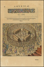
The earliest obtainable separately issued regional map of Brazil, from Gastaldi's Delle Navigazione e Viaggi, published in Venice in 1606.
The map represents an extremely early and inaccurate depiction of Brazil, more pictorial than geographical. The inland area is virtually undescribed. The Amazon and the Rio de Plata originate from a volcano deep in the jungle. Beyond that is "Terra Non-descoperta" (an undiscovered land).
Along the coast, Portuguese and French visitors are seen together with local Indians and the ocean is filled with French and Portuguese ships with fish and with monsters. Modern Rio de Janeiro is south of C. frio (Cabo Frio), and Salvador or Bahia, at C. de todos Santos.
Suarez notes of this map:
"the vignettes include an early depiction of the hammock, for which the Brazilian Indians are famous, and the parrot. Hunting and domestic scenes abound, but Ramusio has spared the viewer the cannibal cliché already popularized on other maps."
This is an essential map for Brazil collectors.
States and Editions
Two woodblocks were used in the printing of this map. The first was used between 1554 and 1565 before being destroyed in a fire. This first edition is identifiable by the spelling "Discoperta" instead of "Descoperta".
The second block was reused in 1606, identifiable by the presence of wormwood damage.
Ramusio’s Navigationi et Viaggi
Ramusio, a Venetian civil servant, spent decades gathering images, accounts, and sources for a massive collection of travels and voyages. He wanted to update the geographic knowledge of antiquity, which was being challenged by European interactions with the Americas, Africa, and Asia. He especially wanted his work to be useful to mapmakers in updating their representations of the known world.
One of the larger printing projects of the sixteenth century, the collection eventually appeared in three volumes. They were published by Tommaso Giunti in Venice and only in a later edition, in 1563, was the author revealed to be Ramusio. The first volume was published in 1550 and held information about Africa, India, and the East Indies. The second was published in 1559 and discussed Russia, the Middle East, and Central Asia. The third volume, published before the second in 1556, held information about the Americas.
The second volume was delayed because of a large fire in Ramusio’s workshop in 1557; the flames ruined the volume’s woodblocks, forcing the second edition to be published two years later and with no maps. The maps that were included in the other volumes were most likely the work of Giacomo Gastaldi, who tutored Ramusio’s son. While the first volume had three maps and plans, and the second none due to the fire, the third volume had nine maps of the Americas, Africa, and the East Indies.
The work was an important milestone in publishing and each edition was reprinted several times: volume I in 1550, 1554 (with additions), 1563 (with an additional leaf mentioning Ramusio as author), 1588, 1606, and 1613; volume II in 1559, 1574 (with additions), 1583 (further additions), and 1606; and volume III in 1556, 1565 and 1606 (with additions). Only once, in 1606, were all three volumes reprinted in the same year.
Giovanni Battista Ramusio (1485-1557) was an Italian geographer who worked within the Venetian Empire. His father had been a magistrate and he himself served as a civil servant to Venice. He served throughout Europe, allowing him to build up a network of informants and a collection of travel materials. He compiled this information into his enduring masterpiece, Navigationi et Viaggi, in 1550 (first volume) and 1556 (third volume). The second volume appeared after his death in 1559, as the original manuscript had been destroyed by a fire.

![A collection of five watercolor drawings from the Luso-Hispanic Border Commission in the Amazon Basin, drawn by its Spanish commanding officer: Parte del camino de tierra de Quito al R. Napo (Lamina I); Vista de la Poblacion y Fortaleza de S. Fran[is]co Xavier de Tabatinga (Lamina V); Vista del Salto grande del Rio Yapurà desde la dist.a de 3 Leguas (Lamina X); Vista del Grande Salto inaccesible del Rio Yapurá (Lamina XI); Los Pongos del Rio Marañon [Lamina XVIII].](https://storage.googleapis.com/raremaps/img/small/100698.jpg)