|
||

|

|
|

|
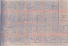
Early trekking map of central Nepal, focused on the region just to the northeast of Kathmandu, along the border with Tibet.
The map shows the region in extremely fine detail, with contours, rivers, roads, towns, and more shown. This map was produced locally, in Kathmandu, for the trekkers that started to arrive in the region to explore its natural beauty in the late 20th century.
An inset in the lower left shows the course of the Helambu Trek and the local valley. Mountains in the region include Langshisa Ri.
Provenance
This map came from the collection of Oleg Polunin. Educated at Magdalen, Oxford, and having taught at Charterhouse, Polunin wrote several important texts for students of botany. His early work focused on European flowers, but later he started studying wild flowers in the Himalaya. He was awarded the Linnean Society's H. H. Bloomer Award in 1983, shortly after the publication of this map. He died in 1985.
The map includes a manuscript note showing the route of a trek taken in the mountain range, which likely relates to Polunin's work in the region.