


|
||

|

|
|

|
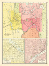
The Golden Age of the Twin Cities Streetcar.
One of the quintessential maps of the Twin Cities, oft-reproduced online but seldom encountered in commerce.
The pamphlet was issued to promote the routes of the Twin Cities Lines electric streetcar company, which ran between Stillwater and Tonka Bay, through extensive networks in Minneapolis and Saint Paul. All of this is represented in a pleasing color-printed map of the area. Some boat routes (namely on Lake Minnetonka) are illustrated as well.
The Twin Cities streetcars hold an important place in the imaginations of many residents, and their destruction (largely instigated by bus and car companies) an infamous chapter in Twin Cities history. The back of the pamphlet includes photographic illustrations of streetcars running through rural areas with nothing like the population density one would expect would be necessary to support such infrastructure.
In over a decade of looking for this kind of material, we have encountered very few examples of this image, which is a popular digital reproduction online.
This is a genuine example of the 1910 issue.
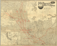

![[Red River Valley] Map of the Wheat Region Red River Valley and adjoining Countries in Dakota and Minnesota Published by A.J. Harwood, Fargo, D.T.](https://storage.googleapis.com/raremaps/img/small/70591.jpg)