|
||

|

|
|

|
The First Printed Map of New England and New France
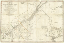
A nice example of the first printed map devoted to New England and New France, showing the eastern seaboard from New York Bay to the Gulf of St. Lawrence. This map appeared in Ramusio's highly important work, Navigationi et Viaggi.
The map is based on the information collected during Giovanni da Verazanno's 1524 and Jacque Cartier's 1534 voyages to the New World. Verrazano was particularly important in exploring the Atlantic coastline up to New Brunswick, while Cartier ventured into the Gulf of St. Lawrence. Verrazano's discovery of New York Harbor was a particularly important moment in the exploration of the Americas. The map reflects Giacomo Gastaldi's attempt to synthesize the information collected by these two voyages for the third volume of Giovanni Ramusio's Navigationi et Viagi, which was focused on the discovery of the Americas.
The map is the first to use the name New France and one of the earliest to delineate New York Harbor and Manhattan with any accuracy. Cohen and Augustyn call this the best surviving early map to illustrate Verrazano's discovery of New York Harbor, visible in the lower left of the map. Manhattan is pictured as a peninsula named Angoulesme. This name, which Verrazano bestowed on his discovery, refers to Francis I's title before he became king. This name never was picked up for general usage and soon disappeared from maps. From New York, Verrazano continued further north, visiting Newport Bay, here called Port Real, and Narragansett Bay, named as Port du Refuge. Verrazano skirted the New England coast further north, which is why the map is missing the familiar shape of Cape Cod and also the reason that the distance between the bays of southern New England and the islands around the Gulf of St. Lawrence are so foreshortened.
The northern region around the Gulf of St. Lawrence is based on Cartier's voyage. Terra Nuova (Newfoundland) is shown as comprised of several islands and the St. Lawrence River is depicted running west from the Gulf, eventually meeting with the Hudson River north of Angouleme. This may reflect an incorrect belief that Cartier and Verrazano met while exploring these rivers.
One unique feature of Ramusio's map is the long mass running across the bottom of the map and then upwards on the right side. The most likely explanation is that this is a depiction of the Grand Banks, but some have suggested that this may be the Gulf Stream.
The map also provides a rich tapestry of images depicting the indigenous Indians, showing scenes from their daily lives, along with a look at the cod fisheries in the northeastern portion of the map, perhaps the first European industry in the New World. Other Europeans can be seen throughout the North American coastline.
This map is based on Gastaldi's Tierra Nueva, with a strong resemblance particularly in the coastal geography, though this map possesses increased detail. Further, the earlier map is much smaller, and shows a much larger portion of the North American coastline.
The map's cartographic importance is simple: this is the first printed map to focus solely on New England and southeastern Canada, an area which would become important a century later. Further, the map provides a fascinating interpretation of some of the earliest voyages to the New World, at a time when this region was still all but unknown to Europeans.
To conclude, Coolie and Verner describe the map as such:
"No matter how the map is approached and interpreted, it raises puzzling and unanswerable questions. In fact, it is something more than a mere attempt at geographical description. It is also an illustration of the resources and inhabitants of a new country, and as such it points to the growing realization among Europeans that if Cathay could not be reached by a westward sailing, the country that intervened might itself hold promise."
States of the Map
The map is known to exist in 3 states. All of Ramusio's map printing woodblocks were burned in a fire in November 1557. As such the second and third states are from the second printing woodblock. The states can be identified as follows:
- 1556 (Block 1): Pages 424 and 425. Trees are rounded, with no weeping willows.
- 1565 (Block 2): Pages 424 and 425. Two weeping willows added at far left, above and below "Ponente."
- 1606 (Block 2): Pages 353 and 354. Signs of woodworm damage (blank spots) appear throughout the map.
Ramusio’s Navigationi et Viaggi
Ramusio, a Venetian civil servant, spent decades gathering images, accounts, and sources for a massive collection of travels and voyages. He wanted to update the geographic knowledge of antiquity, which was being challenged by European interactions with the Americas, Africa, and Asia. He especially wanted his work to be useful to mapmakers in updating their representations of the known world.
One of the larger printing projects of the sixteenth century, the collection eventually appeared in three volumes. They were published by Tommaso Giunti in Venice and only in a later edition, in 1563, was the author revealed to be Ramusio. The first volume was published in 1550 and held information about Africa, India, and the East Indies. The second was published in 1559 and discussed Russia, the Middle East, and Central Asia. The third volume, published before the second in 1556, held information about the Americas.
The second volume was delayed because of a large fire in Ramusio’s workshop in 1557; the flames ruined the volume’s woodblocks, forcing the second edition to be published two years later and with no maps. The maps that were included in the other volumes were most likely the work of Giacomo Gastaldi, who tutored Ramusio’s son. While the first volume had three maps and plans, and the second none due to the fire, the third volume had nine maps of the Americas, Africa, and the East Indies.
The work was an important milestone in publishing and each edition was reprinted several times: volume I in 1550, 1554 (with additions), 1563 (with an additional leaf mentioning Ramusio as author), 1588, 1606, and 1613; volume II in 1559, 1574 (with additions), 1583 (further additions), and 1606; and volume III in 1556, 1565 and 1606 (with additions). Only once, in 1606, were all three volumes reprinted in the same year.
Giovanni Battista Ramusio (1485-1557) was an Italian geographer who worked within the Venetian Empire. His father had been a magistrate and he himself served as a civil servant to Venice. He served throughout Europe, allowing him to build up a network of informants and a collection of travel materials. He compiled this information into his enduring masterpiece, Navigationi et Viaggi, in 1550 (first volume) and 1556 (third volume). The second volume appeared after his death in 1559, as the original manuscript had been destroyed by a fire.
Giacomo Gastaldi (1500-1566) is considered the foremost Italian cartographer of the sixteenth century, alongside Paolo Forlani. His skills of compilation are comparable to those of Mercator and Ortelius, yet much less is known of his life than of his two contemporaries. Gastaldi was born in Villafranca, Piedmont, but had established himself in Venice by 1539. He originally worked as an engineer, but turned to mapmaking from the 1540s onward.
It was in Venice where he made his reputation as an engraver, geographer, and cosmographer; for example, he was asked to fresco maps of Asia and Africa in the Palace of the Doge, or the Council of Ten, Venice’s governmental body. He also frequently consulted on projects for the Savi sopra la Laguna, drawing maps for this body which oversaw the regulation of fresh and salt water around Venice.
His contemporaries also recognized his skill, as he was named cosmographer to the Republic of Venice, was a member of the Accademia Veneziana, and was a major source for other geographers and mapmakers including Camocio, Bertelli, Cock, Luchini, and Ortelius. He even had his own distinct style of copper engraving that made him a pioneer in his day and makes his works iconic today.
Gastaldi enjoyed an especially productive relationship with Giovanni Battista Ramusio, Secretary of the Venetian Senate, who used Gastaldi's maps for his famous travel account collection, Navigationi et Viaggi. Gastaldi also tutored Ramusio's son in cosmography.

![(Colonial New England Ironworks) [Early 19th-century manuscript copy of 1674 New England land transaction involving John Gifford; mention of early ironworks in Massachusetts]](https://storage.googleapis.com/raremaps/img/small/93113.jpg)