|
||

|

|
|

|
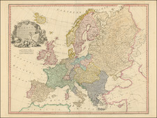
Superb Louis XV Wall Map of Europe. With Rare Text Panels.
A detailed and ornate wall map of Europe, surrounded by beautiful vignettes of the continent and its peoples.
This rare survival was published in Paris in 1730, early in the reign of King Louis XV. The map presents eighteenth-century Europe as it stood at the end of the Spanish and Ottoman hegemonies and during a period of growing French, English, and Prussian ambitions. The map acknowledges the power of the French royal family throughout and is dedicated to the Dauphin.
The detail on the map is truly remarkable and reflects the growing French desire to create maps based on reliable scientific sources rather than myth. This has its largest effect in the eastern part of this map, in Russia, which saw many visiting French cartographers during this period. The map extends from Greenland and Iceland in the northwest and encompasses Scandinavia, Russia, Asia Minor, and North Africa, in addition to the bulk of the European continent. Ukraine is labeled "Petite Tartarie."
The map contains toponyms and information about past explorers and current trade routes. In the north, an explanatory note details the possibility of more terra firma, for example. Boats pepper the waters of the Black and Mediterranean Seas, as well as the Atlantic. Toward Greenland, with an imprecise shore, ships chase after whales, a nod to the rich whaling grounds once found in that area.
The map is surrounded by vignettes that depict the peoples and capitals of the continent. They celebrate, starting from the upper left corner, the French, Danes, Dutch, Germans, English, Muscovites, Portuguese, Spanish, Ukrainians, Laplanders, Greenlanders, Turks, Hungarians, Poles, and Swedes. Each image is a collection of the well-known - some might say stereotypical - tropes that defined each group from a French perspective. For example, the Spanish are described as serious and grave, not to mention Catholic, with an added depiction of a grand bullfight at Plaza Mayor, Madrid.
The title splits the aforementioned vignettes at the center top and is flanked by man's state in nature on one side and sleepy scholars on the other. All the illustrations on the map seem aimed to communicate the high level of civilization enjoyed by many Europeans, particularly when compared to indigenous peoples. This title references the learned men of the Academie Royale. Founded in 1666, the Academy is one of the oldest learned societies in Europe. It was created to foster and protect French scientific interests, one of which was geography. Headquartered in the Louvre, members would present new ideas and consult each other about experiments. The members had excellent international contacts and frequently were the main conduit for circulating and recording geographic knowledge in map form.
The present map is a fine example of the genre of wall, or parlor, maps that enjoyed an iconic place in seventeenth and eighteenth-century Europe. Large, highly decorative, and expensive productions, they were considered to be the ultimate signs of wealth and intellectual sophistication. In this vein, such wall maps appeared prominently in works of fine art, most notably the paintings of Johannes Vermeer. Displayed in the salons of leading merchants and noblemen, the maps were especially prone to damage, and their survival rate is extremely low. The present map is truly exceptional, for it is preserved in remarkably fine condition.
Publication History
The first edition of this map appeared in 1695, published by Nicolas de Fer, and lacked decorative vignettes. They are present by the time of the 1723 Guillaume Danet edition, the precursor to this 1730 edition. Later editions of this map were issued using different copper plates and were printed as late as the 1770s, with the latest ones published by Louis Charles Desnos.
Nicholas de Fer (1646-1720) was the son of a map seller, Antoine de Fer, and grew to be one of the most well-known mapmakers in France in the seventeenth century. He was apprenticed at twelve years old to Louis Spirinx, an engraver. When his father died in 1673, Nicholas helped his mother run the business until 1687, when he became the sole proprietor.
His earliest known work is a map of the Canal of Languedoc in 1669, while some of his earliest engravings are in the revised edition of Methode pour Apprendre Facilement la Geographie (1685). In 1697, he published his first world atlas. Perhaps his most famous map is his wall map of America, published in 1698, with its celebrated beaver scene (engraved by Hendrick van Loon, designed by Nicolas Guerard). After his death in 1720, the business passed to his sons-in-law, Guillaume Danet and Jacques-Francois Benard.
![(Prussian Octopus) En 1788 Mirabeau disait deja: La Guerre est l’industrie Nationale de la Prusse [Already in 1788 Mirabeau was saying: War is the national industry of Prussia]](https://storage.googleapis.com/raremaps/img/small/76554.jpg)
![[ First World War) ] The World Cannot Live Half Slave, Half Free -- The Prussian Blot -- 100,000,000 People Already Enslaved By Germany](https://storage.googleapis.com/raremaps/img/small/68731.jpg)