|
||

|

|
|

|
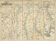
One of Mark Twain's Sources For Huckleberry Finn
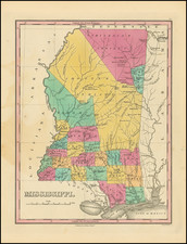
Impressive Civil War-era wall map of the Mississippi River from St. Louis to the Gulf of Mexico, delineated in five sections and showing the river in intricate detail.
Lloyd's map of the Mississippi was the most comprehensive commercial map of the river at a time when the Mississippi River was arguably the single most important commercial thoroughfare in America. Moreover, at the time of its publication, the River was also shared by enemy combatants in the Civil War. As part of this complex relationship, access to the River was shared by enemy combatants with a general policy toward open and free trade between all states on both sides of the war. However, policies imposed by the Confederate states limited the flow of certain goods to the north. In addition, both sides were concerned with the flow of contraband and Kentucky's policy of "Armed Neutrality" raised concerns with neighboring Ohio and Indiana who, despite not having direct access to the River, still relied on it for downstream commerce.
The map is extremely detailed and shows plot-level detail with owners' names marked along the Mississippi north from the delta. Lloyd's map was offered in several formats, including one in which the strips were cut and joined to form one long column. This is often the case with the later 1875 edition of the map.
Interestingly, the map is updated from the first edition to describe the so-called "Grant Vicksburg Cut-Off". This was an abortive attempt by General Grant to have the Williams Canal and across the DeSoto Peninsula, avoid the batteries at Walnut Hill and Vicksburg. Although the project was abandoned in March 1863, the river would accomplish the task on its own by 1876.
The map records the following 1862 Civil War events:
Warrenton - "Destroyed by Gun Boats June 1862"
Grand Gulf - "Shelled by Gun Boats May 18, 1862"
Confederate batteries at Walnut Hill and Vicksburg.
"Johnsons [sic.] killed 1862"
The Lloyd map is a continuation of the mapping of the Mississippi in the tradition of the 1858 Persac Norman's Chart of the Lower Mississippi River (a map that has twice achieved six figures at auction), updated for the Civil War.
Use in Writing Huckleberry Finn
According to the definitive scholarly appraisal of Mark Twain's complete works, Twain consulted Lloyd's map of the lower Mississippi when writing Huckleberry Finn. This should not come as much of a surprise, as Twain was a successful riverboat captain from 1857 until the outbreak of the Civil War in 1861 and would have been well-acquainted with the most up-to-date mapping of the river.
J. T. Lloyd
J. T. Lloyd had offices in London, New York, and Philadelphia. He compiled steamboat directories in 1857 and 1862. He used intaglio plate-transfer lithography to produce this map, which was relatively new at the time of issue.
States
This is the 1863 (1864) second edition of the map, following the 1862 first. The present is a very good example of the wall map format, which when it is rarely encountered is often in poor condition.