|
||

|

|
|

|
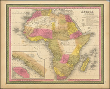
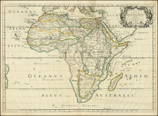
Mapping Africa in the Late-Seventeenth Century
Fine example of Jacob Sandrart's map of Africa, one of only two maps engraved by Johann Baptist Homann prior to 1690.
The map is a close model after De Wit’s, showing the entirety of the African continent along with a slice of Southern Europe and much of the Arabian Peninsula.
The continent is shown in detail, with towns, rivers, lakes, and political units. Madagascar is arced eastward in a manner characteristic of maps of this period. Interspersed throughout are tiny monkeys, lions, ostriches, cheetahs, rhinos, and elephants. At sea are many European vessels in full sail, emphasizing the importance of Africa for trade in goods and, tragically, people.
Perhaps the most noticeable feature on the map are the continent’s waterways. Of these, the Niger and the Nile stand out. The Niger flows from a lake called Borno. The Nile is shown as originating in two lakes in South-central Africa, a common portrayal of its headwaters in this period (see below).
The substantial title cartouche in the lower left reveals much of the biased European thinking regarding Africa. It shows Africans in robes and turbans with a ruler under a parasol. Nearby, mounted men ride with swords and a man’s head held aloft. In the water, another man seems about to behead another victim. On the other side, a naked mother breastfeeds an infant. In the foreground, a lion bows to the ruler, accompanied by a bushy-tailed dog, snakes, and a lizard. These associations with barbarity, despotism, and savagery were common conceptions among Europeans at the time, feeding the Transatlantic slave trade and colonialism.
Theories on the source of the Nile
Typically, mapmakers thought the Nile River rose from twin lakes south of the equator, which were near the Mountains of the Moon. Streams from the mountains fed the lakes. Ptolemy describes such a lakes-and -mountains layout in his works, although the precise identification of the Mountains of the Moon may have been a fourth century addition to his text.
Sixteenth century mapmakers, including Waldseemuller, chose to follow the Ptolemaic model. This was typical of cartographers at the time, who had abandoned Ptolemy’s coastlines in favor of the more recent Portuguese outlines yet who also clung to Ptolemaic place names for the interior of Africa well into the nineteenth century.
Giacomo Gastaldi, most likely thanks to sources he read via the travel writer Ramusio, chose to abandon the Mountains of the Moon entirely in his 1564 map of Africa. Instead, he drew a massive central lake from which flows the Nile, Zaire (Congo), Cuama (Zambezi), and Spirito Sancto (Limpopo) Rivers. To the east is another, smaller lake at roughly the same latitude, which also feeds part of the Nile. Therefore, Gastaldi created an entirely different view of the interior of Central Africa, while still embracing Ptolemy’s twin lakes theory.
In Ortelius’ Africa map included in the original 1570 Theatrum, he also included a large central lake, called Cafates. He rejected the name of Zaire-Zembere used by Gastaldi. To the east and just slightly north was another, smaller lake. Rivers from the north of both lakes wend northward and join to form the Nile. The Zaire (Congo) flows from the northeast of Lake Cafates, while the Zuama (Zambezi) exits at the south of the lake. It branches into the Spiritu Sant, or the Limpopo.
In his regional Prester John map, however, Ortelius has brought back the Mountains of the Moon. The Nile still branches from two lakes, but the larger of these is now called Zaire, as it had been with Gastaldi.
Clearly Ortelius continued to review sources between drafting the Africa map and the regional map. Contemporaries like Mercator, as well as later mapmakers, followed mainly in the two-lake model, including iterations of the Mountains of the Moon for centuries. Here, Sandrart has followed de Fer in showing the two lakes, but without the mountains as a major feature.