|
||

|

|
|

|
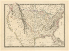
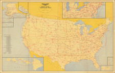
The Great Overland Route.
Rare folding map of the United States railway system during the 1870s.
The map focuses on the routes operated by and connecting with the Chicago, Rock Island, and Pacific Railway, one of the great transcontinental railway operators of the 19th century. These routes weave across the West, eventually connecting with the Central Pacific, the Atlantic Pacific, and the Southern Pacific.
Dakota is still shown as a single state, with few railway connections. Oklahoma is named Indian Territory. An inset world map appears in the lower left showing an around-the-world route that incorporates the railroad.
The map was copyrighted in 1879, and this example was issued in December of 1881. This an early example of a style of railroad mapmaking that would continue through the 1880s and into the 1890s.
Rarity
We locate only three copies in OCLC of the 1879 map, at the Library of Congress, Pennsylvania State University, and the National Library of Scotland.