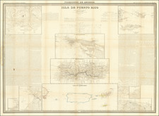
|
||

|

|
|

|
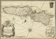
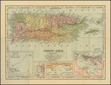
A nice example of Bellin's maps of Puerto Rico and St. Croix, in the US Virgin Islands. Detail is extensive on these two islands, with cities, mountain ranges, anchorages, and more shown. Detail is particularly focused on navigational features, showing many banks and naming many points.
The style in which these maps are drawn make them hallmarks of 18th century navigational cartography. The faint blue coloring to the sea and rivers brings out additional relief on land. The depictions of mountains is suggestive. Further, the names (in French), such as "drowned land," "the fort," or "coffin of the dead," are simple but evocative.
At the time that this map was made, Puerto Rico was controlled by the Spanish, while St. Croix had recently been purchased by the Danish West Indies Company and brought under monarchical control. Alexander Hamilton would move back to St. Croix the year after this map was made where he would spend his formative years on the island, before going to New York for college. In Puerto Rico, the island was generating increased imperial interest, and would play a major roles in the Caribbean conflicts of the second half of the 17th century.
This work originally appeared in Bellin's Le Petit Atlas Maritime, ou Recueil de Cartes de Plans des Quatre Parties du Monde. This small-sized pilot was a delightful maritime atlas, showing many places of interest around the world.
Jacques-Nicolas Bellin (1703-1772) was among the most important mapmakers of the eighteenth century. In 1721, at only the age of 18, he was appointed Hydrographer to the French Navy. In August 1741, he became the first Ingénieur de la Marine of the Dépôt des cartes et plans de la Marine (the French Hydrographic Office) and was named Official Hydrographer of the French King.
During his term as Official Hydrographer, the Dépôt was the one of the most active centers for the production of sea charts and maps in Europe. Their output included a folio-format sea atlas of France, the Neptune Francois. He also produced a number of sea atlases of the world, including the Atlas Maritime and the Hydrographie Francaise. These gained fame and distinction all over Europe and were republished throughout the eighteenth and even in the nineteenth century.
Bellin also produced smaller format maps such as the 1764 Petit Atlas Maritime, containing 580 finely-detailed charts. He also contributed a number of maps for the 15-volume Histoire Generale des Voyages of Antoine François Prévost.
Bellin set a very high standard of workmanship and accuracy, cementing France's leading role in European cartography and geography during this period. Many of his maps were copied by other mapmakers across the continent.
![A New & Accurate Map of the Island of Cuba [on sheet with:] A New & Accurate Map of the Islands of Hispaniola and Porto Rico . . .](https://storage.googleapis.com/raremaps/img/small/77174.jpg)