|
||

|

|
|

|
The Only Obtainable Mercator World Map. A True 1587.
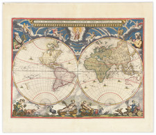
An attractive example of Rumold Mercator’s map of the world, printed in Geneva (or Duisburg) in 1587. The map is based on Gerard Mercator’s celebrated 1569 world map and was made while Gerard was still alive (1512- 1594). This is the only collectible world map with direct input from Gerard Mercator, the greatest geographer of his era. Both his 1538 and 1569 world maps are unobtainable rarities.
The present work is a reduced version of the 1569 wall map of the world, on which the revolutionary Mercator Projection was introduced. Oddly, this folio version recast the map into a double-hemisphere format; Rumold chose not to employ his father’s namesake projection.
To the left is the western hemisphere. The prominent bulge in South America, a characteristic introduced by Gerard Mercator and evident on his 1569 world map, has been retained here. Tierra del Fuego forms part of a gigantic southern continent that continues in the eastern hemisphere. At the north pole, two of the four islands that Gerard Mercator thought surrounded the pole are evident. There is also a suggestion of a Northwest Passage via the Straits of Anian.
"Anian" is thought to derive from Ania, a Chinese province on a large gulf mentioned in Marco Polo’s travels (ch. 5, book 3). The gulf Polo described was actually the Gulf of Tonkin, but the province’s description was transposed from Vietnam to the northwest coast of North America. The first map to do so was Giacomo Gastaldi’s world map of 1562, followed by Zaltieri and Mercator. The Strait then became shorthand for a passage to China, i.e. a Northwest Passage. It appeared on maps until the mid-eighteenth century.
Quivira, south of Anian, refers to the Seven Cities of Gold sought by the Spanish explorer Francisco Vasquez de Coronado in 1541. In 1539, Coronado wandered over what today is Arizona and New Mexico, eventually heading to what is now Kansas to find the supposedly rich city of Quivira. Although he never found the cities or the gold, the name stuck on maps of southwest North America, wandering from east to west.
In the eastern hemisphere, Japan appears as a large round island. The islands of Southeast Asia are arrayed with relative accuracy for the time. To the south, the names of Beach, Maletur, and Lucach reveal again Mercator’s use of toponyms from Marco Polo. Farther east on the southern continent is Psitacorum regio, which appeared on Gerard Mercator’s 1541 globe and his 1569 world map. It was supposed to have been sighted by Portuguese sailors.
The hemispheres are ringed with impressive strapwork, adding a pleasing decorative element to the map. At the top center is an armillary sphere. It is paired with an elaborate compass rose in the bottom center.
States
According to Shirley (157) one can differentiate between early editions of the map by the appearance or not of the letterpress text "Lectori S.P." below the map image. Unpublished research by Belcher and Clausen has revised that slightly. They have shown there to be at least four versions of the early (i.e., pre-1595) edition of the map, as follows:
1587A: Without the engraved credit in the strapwork decoration at the bottom center, "Duysburghi Cliuorum Typis Aeneis". And without the letterpress text below the engraved image.
1587B: Without the engraved credit. But with the letterpress text below the engraved map reading "LECTORI S.P. [etc.]".
1587C: With the engraved credit in the strapwork decoration at the bottom center, "Duysburghi Cliuorum Typis Aeneis". And with the letterpress text. There is no typesetting change between this map and 1587B.
1587D: With the engraved credit in the strapwork decoration. But without the letterpress text below the map image.
While 1587C must necessarily follow A and B, it has not been determined if A or B was published first.
The present map is an example of the 1587C issue.
Publication
The map was first printed as part of Isaac Casaubon’s publication of Strabo’s Geographia in 1587. Then, the map became a staple in the Mercator atlas, which Rumold compiled. For a detailed treatment of the 1595 first atlas edition of the map, see this entry. In 1603, the plate developed cracks in the top edge of the plate; two distinct cracks can be seen in the title.
The Mercators only published two editions of their atlas (1595, 1602) and then sold the plates to Jodocus Hondius. Hondius and his collaborators reissued the map in many of the atlases from 1606 until the 1630s. It was included in both Latin and French editions and, later, in English editions. The plate was never changed during its entire print run.
The map proved very influential, as did the entire Mercator atlas. The world map was copied with some alterations by Petrus Plancius in 1590 and reproduced by Hieronymo Porro in 1596 in Venice.
![A General Atlas Containing Distinct Maps Of all the known Countries in the World. Constructed from the Latest Authority [Binder's title: Lucas's Cabinet Atlas]](https://storage.googleapis.com/raremaps/img/small/80266.jpg)