|
||

|

|
|

|
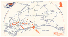
Detailed World War II-period survey map of the La Jolla area, showing fine detail for the region.
The map extends northwest to just beyond the Scripps Pier and the La Jolla Farms area, east to the Navy Field Landing Field and Mooring Mast, and south to Ocean Beach and University Heights.
There is excellent detail in La Jolla, including the Caves, Goldfish Point, the Cove, Point La Jolla, Rocky Pt. Sea Rock and Whale View Point. Hidden Valley and Ardath Road are shown as dirt roads. La Jolla Mesa, La Jolla Hermosa, Bird Rock and False Point are also named. A break in development appears between Via del Norte and Palomar.
La Jolla High School is shown, the final stop on the San Diego Electric Railway, which extends south through Pacific Beach and Mission Beach, before crossing into Ocean Beach and heading inland to Point Loma and downtown San Diego.
In Pacific Beach, PB Jr. High School and PB Elementary are named, as is Crystal Pier and the Brown Military Academy. Crown Point is named, but to the south, the dredging work that creates the south part of Mission Bay has not commenced.
Interesting early features include:
- Rosedale Landing Field
- Pacific Beach Siding off the old railroad line
- Ladrillo
- An Airway Beacon in Claremont
The map shows the following communities:
- Morena
- Bayside Village
- Overlook
- Crown Point
- Selwyn
![(National City & Otay Railway) Plat of the located lines of the Tia Juana & Oneonta Branches of the Otay Railway [with] Plat of the National City & Otay Railway Sheet 2 from South Line of San Diego to Otay City [with] Plat of the National City & Otay Railway Sheet 3 from Sweetwater Junction to La Presa](https://storage.googleapis.com/raremaps/img/small/96209.jpg)