|
||

|

|
|

|
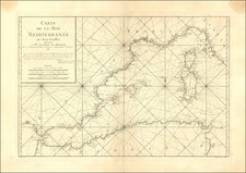
16th-Century Portolan Chart of the Mediterranean. Attributed to Joan Martines, Royal Cartographer to Philip II and Likely Representing an Early Example of His Work.
Fragment of an unfinished manuscript portolan chart, showing the Mediterranean in its entirety and highlighting the cartographic prowess and expertise of 16th-century Sicilian school cartography.
The portolan shows the Mediterranean from the Bay of Almeira, in Spain, eastwards to the Holy Land. Throughout the chart, thousands of port cities and coastal features are named, with important cities denoted in red and the most important cities depicted pictorially. Foremost among the great trading ports of the Mediterranean are Genoa, shown with its half-moon bay, and Venice, seen behind its lagoon. In addition to the Mediterranean, the map covers almost all of the Black Sea. Eleven cities are shown pictorially, with flags indicating other major settlements.
Portolan charts are the earliest form of sea chart to survive today and were produced around the Mediterranean as a navigational aid. Today, portolan charts, particularly those from the 16th century or earlier, are very rare on the market. This chart was drawn on a vellum sheet, the traditional medium for portolans. The durable material was more water and climate resistant than paper. Some of the most prominent features on the portolan are the compass roses and the emanating crisscrossing rhumb lines. These were used both by the chart maker to correctly position features on the map and for ship captains to plot their courses. This example of a portolan lacks coloring in some decorative elements, namely some coloring of flags, buildings, and compass roses. These were the last features to be painted on a portolan, after completing the necessary geographic features. Unfinished portolans, like this one, are extremely rare today. It stands to reason that less-adorned, or unfinished, portolans were more quickly repurposed for their vellum (as in the case of this map) than their more flamboyant counterparts.
Attribution
This chart is attributed to Joan Martines. His first known work was an atlas produced in Messina in 1556. He remained in Messina until at least 1587. His later work is notable for incorporating the mapmaking techniques of northern Europe, as seen in his 1587 atlas held by the Library of Congress. In 1590, he was appointed Royal Cartographer by Philip II to succeed Domenico Vigliarolo, but it would seem that he would pass away the following year as there is no record of him or his work after 1591. He does not appear to have had an immediate successor in his position as Royal Cartographer.
The attribution to Martines is near certain. The most obvious similarity to his known oeuvre lies in the design of the cities. Genoa and Venice, in particular, are nearly identical to other examples of Martines's depictions of the two cities, particularly in his early work such as this 1567 chart (the MEDEA project dates the chart to 1559, but the chart clearly says "1567") held by the British Library. On both the present example and the British Library example, the Bay of Genoa has a column to the west and a single building at the end of a promontory to the east. A similar pattern can be seen with Venice, which has a bridge to the east of the city with a slip extending into the water. That pattern again appears on a 1584 Martines portolan held by Trinity College, Cambridge.
The decorative similarities are extensive, but it is the toponyms shown that cement the connection with Martines. According to Tony Campbell's list of toponyms to appear on portolan charts, the only other appearances of the toponym Sutri (on Italy's west coast, in red) after 1403 are on Martines charts from 1570 and 1591. There are further tell-tale signs. Ventimiglia, near the present-day French-Italian border, is spelled "xx : milla." While the spelling "xxmilia" sometimes appears on charts, the only other exact match for spelling, with the inclusion of the colon, that we have thus far identified is on the Trinity College Martines chart.
Portolan charts
The word "portolan" derives from the Italian portolano or portulano, meaning pilot book. Navigators would have used these charts in conjunction with books of written sailing directions, or rutters, as well as instruments, the weather, and the stars to find their way.
In their detail and technical construction, portolan charts mark a revolutionary moment in the history of cartography. Although their initial creation and development is unknown—they are assumed to be a mixture of Medieval sailors’ knowledge, emerging ideas about geography and mathematics, and perhaps contributions from Arab or Byzantine sources—their importance to navigation and Western civilization are undeniable.
Portolan charts were the first maps to show the Mediterranean and the Black Sea in a recognizable form. Previous Medieval maps, namely the mappaemundi, showed a symbolic and deeply religious world that was more concerned with spiritual hierarchy and space than with geographical precision. Portolans, while sometimes containing religious imagery, were different. They strove to show proportionate and accurate spatial relationships. They were based on the first-hand knowledge of sailors and underline the growing importance of long-distance, overseas trade for Mediterranean and European peoples.
Portolan charts were used from the late Medieval period until the late-seventeenth century, with the first known portolan, the Carte Pisane, dating to ca. 1290. This type of distinctive and decorative manuscript chart was by and large overtaken in the late-sixteenth century by printed charts and nautical atlases, the first of which was Lucas Jansz Waghenaer’s Spieghel der zeevaerdt in 1584. However, until the 1580s, portolans remained the only way to safely navigate coastal waters. Throughout the seventeenth century, their use slowly declined, although they retained a significant following in Italy and the Iberian Peninsula.
A Note on Unfinished Portolans
The following is excerpted from Corradino Astengo's essay in Volume 3 of the History of Cartography, Part 1, "The Renaissance Chart Tradition in the Mediterranean," pages 186-187:
Naturally enough, unfinished charts give us some help in understanding the order in which they were drawn up—though even here, they tell us only about the procedure followed by a particular chartmaker and nothing about generally established rules. As a first example, one might mention an anonymous nautical chart that has been rescued from use as material for book binding . . . This shows only the eight main winds (in black) without the half- and quarter-winds, together with a traced coastline (also in black), but without any islands (except Euboea) or place-names; there are also circles or series of concentric circles designed to contain the ornamentation for the thirteen compass roses. The chartmaker seems to have worked in the following order: first he drew the lines for the eight winds, then the outlines of land masses, and finally the circles for the ornamental roses (arranged so that they do not overlap the coastline). Afterward he would have gone on to add the other wind lines and the lines of the half-winds, place-names (both black and red), and finally the ornamental figures that this undoubtedly seventeenth-century work would have contained.
A few unfinished nautical charts are bound in one of the three volumes of manuscript charts prepared by Robert Dudley for his Arcano del Mare and therefore probably belonged to [Dudley] . . .
Another particularly interesting anonymous chart perhaps dates from the beginning of the seventeenth century . . . . Richly decorated with compass roses and miniatures of cities and various animals, the work, however, is totally without place-names. This may well mean that the coastal place-names in red and black were the last things added to a chart—though this one example is hardly enough to establish that this was the general rule. There is also the possibility that this chart—entirely finished in all other respects—had left the cartographer’s workshop for the studio of some expert or scholar who was responsible for inscribing the place-names, perhaps in Greek (some thing that was far from uncommon). However, one would seem to be justified in claiming that the coloring of decoration and ornamentation was the last operation carried out before the addition of the cartographer’s signature, together with the place and date of completion— though of course not all finished works are signed.
A further discussion of the production process by Astengo on page 191 appears to apply to this chart:
Scholars have recognized that at least within the more important workshops there was a further division of labor. Baldacci refers to the presence of amanuenses and draftsmen, but admits that our insufficient knowledge of the way such workshops were organized prevents us from going any further. Campbell points out that a medieval illuminated manuscript was normally the work of a scribe, a rubricator, and at least one painter. Almagià seemed to confirm the extension of this practice to cartography when in his examination of an anonymous chart . . . he found that the scribe had omitted the initial letter from the legends—presumably leaving the space to be filled in by a rubricist or a miniaturist—and that the actual initials were a crude addition by a later hand trying to complete the unfinished text. The same conclusion might be reached in studying the previously mentioned chart that lacks all the red ink place-names; however, another explanation for their absence might be that the amanuensis or cartographer who completed the placenames in black fully intended to go on to those in red, but for some reason or another never did.
Joan Martines was cosmographer who lived and worked Messina (Sicily, Italy) from 1556-1587.
Martine's place of birth is unclear. Most historians believe Martines to be of hspanic ancestry, possibly Mallorcan, Valencian or possibly Catalan and most probably of converted Jewish parents. Uzielli and Nordenskiold concluded that he was Sicilian. In 1591 he moved to Naples after his becoming the Royal Cartographer by Philip II of Spain.
A number of Martines' charts survive in institutional collections. A number of single sheet portolans are known in his hand, but he is perhaps most famous for his portolan atlases. The earliest surviving atlas dates from 1556.
![[ Catholic Missions in the Ottoman Empire ]. Carte Ecclesiastique de L'Empire Ottoman d'apres les Missiones Catholicae](https://storage.googleapis.com/raremaps/img/small/88303.jpg)