This item has been sold, but you can enter your email address to be notified if another example becomes available.


|
||

|

|
|

|
Stock# 86533
Description
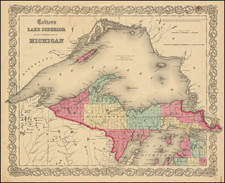
One of the Earliest Printed Maps of Lake Superior.
Fine early map centered on Lake Superior, published by the Society for Diffusion of Useful Knowledge.
This is one the earliest maps to focus on Lake Superior in great detail.
Includes depths, Indians, villages, rivers, islands towns and geographical notes.
An essential map to any Great Lakes collection.
Condition Description
Minor soiling in lower right corner
![[Montana, Calgary, Edmonton, Saskatchewan] Amer. Sep. No. 32. Partie De La Nouvelle Bretagne](https://storage.googleapis.com/raremaps/img/small/54847.jpg)