


|
||

|

|
|

|
With A Massive Sargasso Sea
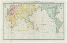
Decorative double hemisphere map of the World, from Chatelain's monumental 7 volume Atlas Historique, published in Amsterdam.
The two hemispheres are divided into a grid with a corresponding key. They are surrounded by a lengthy table, which identifies the locations of principlal cities, bodies of water, islands, and other geographical features across the globe. The routes of prominent explorers are shown mapped out on both hemispheres, along with a list charting their travels. North America is still vastly unexplored with an uncharted western coastline. Australia and New Guinea are joined into one large landmass.
The map includes a massive Sargasso Sea, a region of the Atlantic Ocean bounded by four currents, wich forms a gyre. The Sargasso Sea reports date to Christopher Columbus in 1492, who wrote about seaweed that he feared would trap his ship and potentially hide shallow waters that ran them aground, as well as a lack of wind that he feared would trap them. A 4th poem by the late fourth century author Avienius describes a portion of the Atlantic as being covered with seaweed and windless, drawning on a lost account by the 5th century BC Carthaginian Himilco the Navigator. The Himilico account was known to Columbus, who believed Himilco had reached the Sargasso Sea, as did other early modern explorers. However, modern scholars consider this unlikely.
This fine map is a wonderful example from Chatelain's important text. By combining a wealth of information and geographical observation, with delicate engraving and an uncomplicated composition, this elegant map is a superb example from the golden age of French mapmaking.
Henri Abraham Chatelain (1684-1743) was a Huguenot pastor of Parisian origins. Chatelain proved a successful businessman, creating lucrative networks in London, The Hague, and then Amsterdam. He is most well known for the Atlas Historique, published in seven volumes between 1705 and 1720. This encyclopedic work was devoted to the history and genealogy of the continents, discussing such topics as geography, cosmography, topography, heraldry, and ethnography. Published thanks to a partnership between Henri, his father, Zacharie, and his younger brother, also Zacharie, the text was contributed to by Nicolas Gueudeville, a French geographer. The maps were by Henri, largely after the work of Guillaume Delisle, and they offered the general reader a window into the emerging world of the eighteenth century.
![[ Second World War-Italian Submarine Warfare ] Azione Del Sommergibili Italiani Negli Oceani 1940-1943 [Action of Italian Submarines in the Oceans 1940-1943]](https://storage.googleapis.com/raremaps/img/small/80832.jpg)
![[ World ] Nova Totius Terrarum Orbis Geographica Ac Hydrographica Tabula Auct. Henr: Hondio. . . . 1641](https://storage.googleapis.com/raremaps/img/small/85386.jpg)
![Eastern Hemisphere [with] Western Hemisphere](https://storage.googleapis.com/raremaps/img/small/98321.jpg)

![(Second World War) Der Grossasiatisch-Amerikanische Raum [The Great Asiatic-American Space]](https://storage.googleapis.com/raremaps/img/small/88834.jpg)