|
||

|

|
|

|
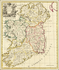
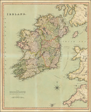
Decorative antique engraved map of Ireland, hand-colored by regions and published by Nicolaus Visscher. The map shows towns, roads, counties, rivers, lakes, castles, and more. Ireland is visible in its entirety, divided into its four provinces: Ulster in the north, Connacht in the west, Leinster in the east, and Munster in the south. Part of Galloway, the Isle of Man, and Cornwall are all also shown. The map includes two marvelous cartouches.
The contrast between the two coats of arms is interesting. The one on the upper left shows the Celtic Harp, a symbol of Ireland, and is framed by passive cherubs. The other coat of arms is in the lower right; this one shows the coat of arms of the United Kingdom and it is framed by a much more regal and powerful scene, including the English lion and the Scottish unicorn. The balance of power is clearly evident; this leaves the impression of looking at a minor constituent kingdom rather than a nation among equals.
The map names William III as King of England, who was known as William of Orange before his ascension to the British throne in 1689.
Nicolaas Visscher II (1649-1702) was a prominent Dutch cartographer and publisher during the late 17th century. He was the grandson of Claes Janszoon Visscher and the son of Nicolaes Visscher I, both of whom were also renowned cartographers in their own right. After his father's death in 1679, Nicolaas Visscher II took over the family's map publishing business.
In 1680, he married Elizabeth Verseyl from Gouda, and in 1682, he obtained a new privilege from the States of Holland and West Friesland to protect his maps and publications from being copied. Visscher II continued the family tradition of producing high-quality maps, atlases, and globes, often with elaborate and decorative elements. He maintained the Visscher family's reputation for accuracy and craftsmanship in the competitive world of Dutch cartography until his death in 1702. After his death, his widow, Elizabeth, and later his son, also named Nicolaas, continued the business until around 1726.