|
||

|

|
|

|
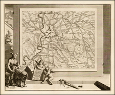
Spectacular map of the region bounded by Nice, Monaco, and the Ligurian coast of Italy in the south, extending north to the French, Swiss and Italian Alps published in Paris by Nicolas de Fer, with cartouches designed and etched by Nicolas Guerard (1648-1719).
Centered on Turin, the Piedmont region and the sources of the Po River, the map shows exceptional detail in the mountains and valleys of the region, augmented by superb original color.
Nicholas de Fer (1646-1720) was the son of a map seller, Antoine de Fer, and grew to be one of the most well-known mapmakers in France in the seventeenth century. He was apprenticed at twelve years old to Louis Spirinx, an engraver. When his father died in 1673, Nicholas helped his mother run the business until 1687, when he became the sole proprietor.
His earliest known work is a map of the Canal of Languedoc in 1669, while some of his earliest engravings are in the revised edition of Methode pour Apprendre Facilement la Geographie (1685). In 1697, he published his first world atlas. Perhaps his most famous map is his wall map of America, published in 1698, with its celebrated beaver scene (engraved by Hendrick van Loon, designed by Nicolas Guerard). After his death in 1720, the business passed to his sons-in-law, Guillaume Danet and Jacques-Francois Benard.
![[ Lazio ] Campagna di Roma, olim Latium: Patrimonio Di S. Pietro; et Sabina](https://storage.googleapis.com/raremaps/img/small/98622.jpg)

![[Spanish Siege of Ostia] Il Vero Disegno Del Sito Di Hostia e Di Porto Con Li Forti Fatti Dal Campo Di Sua Santita et Delli Imperiali Qualisi Resero Adi XXIIII Genaro M. D. L V II . . . .](https://storage.googleapis.com/raremaps/img/small/75401.jpg)