|
||

|

|
|

|
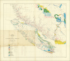
The First Detailed Printed Map of Vancouver Island and Puget Sound
Stunningly intricate map of Puget Sound, Vancouver Island and the Pacific Northwest Coast, the first printed map to show the island and sound to the reading public in such high resolution.
The map traces the shoreline and topography from 45°N to 52°N. The title block reveals that the map was based not only on Vancouver’s original survey, but on Spanish sources as well. These include the manuscript charts of Alejandro Malaspina, who was on the coast at the same time as Vancouver. Indeed, his crew were the first to circumnavigate the island, during which they initially encountered Vancouver’s ships. This Spanish-British collaboration is reflected in the original name for Vancouver Island seen here: Quadra and Vancouver’s Island.
The route lines show Vancouver, in the Discovery, and his second-in-command, Lieutenant Broughton, in the Chatham, as they traversed the waters off what is today Oregon, Washington, and British Columbia in 1792. Their feats include not only the first European circumnavigation of Vancouver Island, but one of the earliest European crossings of the Columbia Bar and a thorough probing of the Juan de Fuca Strait, Admiralty Inlet, and Puget Sound.
The map includes considerable detail, such as sounding depths and anchorages. Prominent landmarks, like Mt. Olympus, namesake of the Olympic Mountains, are also shown. Vancouver and his men also named places for prominent British individuals, like Queen Charlotte, beloved wife of King George III. Mt Rainier is named for Vancouver’s friend, Rear Admiral Peter Rainer.
Vancouver’s stamp on the region is deep, with many of his officers giving their names to important features. Lieutenant Joseph Baker is named in the title; he helped Vancouver prepare his atlas for publication. This is the same Baker for whom Mt. Baker in Washington State is named, as Baker was the first of Vancouver’s crew to see the volcano. Baker had previously served with Vancouver in the Europa in the West Indies.
Then-midshipman Peter Puget was also on the Europa with them. Baker was selected as third lieutenant for the voyage of exploration by Vancouver, with Puget as second lieutenant. Puget’s name, of course, adorns Puget Sound. Vancouver entered the Juan de Fuca Strait in April 1792 and surveyed the sound for two months, with many forays in small boats in the southerly reaches of the sound. On June 4, King George III’s birthday, Vancouver came ashore near what is today Everett, Washington to claim the entire area for Britain. He named it New Georgia, a toponym seen on this map. Vancouver and his crew were floored by the bounty and beauty of the area. Overall, the expedition bestowed 388 place names, many of which are still in use.
Three insets fill the lower left corner, of Gray’s Harbour, Port Discovery, and the entrance to the mighty Columbia River. The former and the latter concern Robert Gray, the first American to circumnavigate the world (1787-90). In command of the Columbia Rediviva, Robert Gray made it over the Bar on May 11, 1792. Later that year, Gray shared his charts with Vancouver at Nootka Sound. Vancouver sent his companion ship, the Chatham, to confirm Gray’s find in October 1792, adding to the details seen here.
Vancouver was lauded as a skilled and thorough hydrographer. He realized soon after arriving on the coast that his two ships were too big and cumbersome to serve as surveying vessels. Therefore, the small boats had to be used for the extensive surveys carried out over three summers. Small groups, led by a lieutenant or other officer, would create sketches and perform observations along the inlets, rivers, and shores. There were then transferred back to the larger ships, where they were reworked and cataloged by the officers.
Back in England, Vancouver personally oversaw the review and preparation of the charts for publication. He worked with several of his officers, including especially Lieutenant Baker. This map featured in the atlas which accompanied Vancouver’s official account of his voyage, published in 1798. It was based on a manuscript chart that was made in late 1792 and brought back to England by Broughton. The account offered readers their first glimpses of many details about the Pacific Northwest, including his namesake island and Puget Sound.
The Nootka Sound Crisis
Geopolitical events overtook the planning of Vancouver’s voyage. Instead of solely a surveying expedition, which was mainly focused on finding possible entrances for a Northwest Passage, the Admiralty ordered Vancouver to check Spanish expansion in the Pacific Northwest, which itself was a response to Russian ships coming farther down the coast from Alaska.
While on a 1788 expedition, the Spanish heard that the Russians had their sights set on Nootka Sound, a port the Spanish had visited and claimed. Spanish captains Martínez and Haro were supposed to ensure that Nootka Sound stayed in Spanish hands. They found that the area was already visited by British ships participating in the fur trade; indeed, when they arrived there were already two American ships and one British ship in the Sound. The latter, the Iphigenia, was seized and then released several days later, with orders to flee. Another vessel, the North West America, was also seized and turned into a Spanish ship, the Santa Gertrudis la Magna, which José María Narváez used to explore the Juan de Fuca Strait. Martinez continued to challenge non-Spanish ships and commanders in the summer of 1789.
Over the next two years, and after a change in regime that installed Don Juan Francisco de la Bodega y Quadra, the Spanish built up a base at Nootka Sound, forming the first European settlement in what is today British Columbia. In summer 1790, Salvador Fidalgo was sent north to claim more Alaskan land for Spain. At the same time, Manuel Quimper was sent south from Nootka; he followed the route of Narváez into the Juan de Fuca Strait and explored among the San Juan Islands. Francisco de Eliza was the next to investigate the Juan de Fuca Strait, in 1791. He was accompanied in the San Carlos by Narváez in the Santa Saturnina. They explored the Strait of Georgia.
While the Spanish base at Nootka had proven useful for exploration, it was still controversial. Alejandro Malaspina, on his global voyage, visited Nootka for a month; he regained the trust of a local leader, Maquinna, and was promised that the Spanish had the rightful claim to land at Nootka Sound. In mid-1792, Bodega y Quadra arrived in Nootka to negotiate the second Nootka Convention; the British sent George Vancouver.
Also in 1792, Malaspina sent two of his officers, Dionisio Alcalá Galiano and Cayetano Valdés y Flores, to survey Vancouver Island in the goletas Sutil and Mexicana. They became the first Europeans to circumnavigate Vancouver Island. En route, they met Vancouver, who was also then surveying in the area. In the same year, Jacinto Caamaño surveyed the southern coast of the island; his maps were shared with the British, who adopted many of his Spanish place names.
Vancouver and Bodega y Quadra entered into negotiations. The two met for several weeks but could not decide on boundaries and settlements; they referred the matter back to diplomats in Europe, but only after agreeing to meet again, at the end of 1792, in Monterey, California. It was from Monterey that Broughton returned to England with the manuscript map that was the base for this map; the manuscript is now held at the UK Hydrographic Office Archives in Taunton.
As for the naming of Vancouver Island, the commander wrote of the event in a letter to the Admiralty. He explains that Quadra requested that it be named for both of them, in honor of their diplomatic relations, he suggested that Vancouver “name some port or Island after us both, in commemoration of our meeting and the friendly intercourse that on that occasion had taken place…and conceiving no place more eligible than the place of our meeting, I have therefore named this land…the Island of Quadra and Vancouver” (Lamb, 247). The dropping of Quadra from the name took place as the British gained more power in the area. For example, by 1824 the Hudson’s Bay Company regularly referred to the island as just Vancouver Island.
Vancouver’s voyage and account
George Vancouver (1757-1798) was born in Norfolk and joined the Royal Navy in 1771. Only a year later, he sailed with Captain James Cook on his second voyage to the Pacific. Vancouver would also sail on Cook’s third, and last, voyage, where Cook was killed in Hawai’i. Although he most likely made rough sketches while with Cook, Vancouver completed his first independent surveys while serving in the West Indies in the mid-1780s. Thanks to this work, his previous Pacific service, and the influence of a powerful patron, Vancouver was selected to lead a new expedition into the South Seas, one of the last large-scale exploratory voyages to the region.
Vancouver was ordered to sail under dual purposes. On the one hand, as outlined above, he was to represent the British at negotiations with the Spanish at Nootka Sound in the Pacific Northwest. Vancouver’s other, and main, purpose was to survey the southwest corner of Australia, Pacific islands, and the Northwest Coast of America. If possible, he was also to find a Northwest Passage.
Vancouver sailed in the Discovery, with the Chatham as escort, in April 1791. First, he made the Australian coast near Cape Leeuwin and surveyed a considerable extent of the southern coast. Next, he sailed to Tahiti and the Sandwich Islands. Then, Vancouver and his crew charted the coast from near San Francisco all the way to Alaska. He completed three surveying seasons on the Pacific Northwest Coast, with winters in Hawai'i.
Vancouver returned to England via Cape Horn in September 1795, over four years after he had led one of, if not the, longest surveying voyages in history. He was promoted to the rank of post captain but the voyage ruined his health and he retired upon return to shore.
He turned his energies instead to producing an authoritative account of his voyage, complete as atlas of detailed charts, as the Admiralty had ordered. Vancouver died in May of 1798. The charts in the atlas are dated May 1, 1798, just ten days before he expired. Vancouver had completed nearly all of the account, half a million words in length, but it still lacked roughly 100 pages. After George’s death, his brother, John, along with Puget and Baker finished the work.
It was published in 1798 in three quarto volumes and accompanied by a folio atlas, where this map appeared. A French edition followed in 1799-1800, followed by a German and a Danish edition, with another English edition in 1801 and another French the next year. Tragically, the plates for the charts were stolen and nothing more was ever heard of them. Thus, later editions have reduced and revised charts on folding sheets.
George Vancouver (1757–1798), a naval officer and explorer, grew up in King’s Lynn, England, the youngest of six children. After entering the Royal Navy in 1771, he served in both the second and third great exploratory voyages of James Cook. During Cook’s second voyage, a three-year quest to find a legendary southern continent, Vancouver received instruction from the astronomer William Wales. During Cook’s third voyage, to the Pacific Northwest, Vancouver was part of the first known group of Europeans to land on the coast of present-day British Columbia.
Vancouver gained valuable navigational, surveying, and mapping experience in the Pacific Northwest during his time with Cook. After returning from Cook’s third voyage in 1780, Vancouver was promoted to lieutenant and spent the following nine years serving on fighting ships, primarily in the Caribbean.
In 1790, Vancouver was chosen to captain the Discovery and charged with a mission to discover and chart the vast areas of the Pacific that were still unknown, in part to locate a Northwest Passage between the Atlantic and Pacific Oceans. This four-year voyage of discovery circumnavigated the globe and eliminated the possibility of an inland Northwest Passage. During many months of surveying, Vancouver produced detailed regional maps of the Northwest Coast, as far north as Alaska. He also established several hundred place-names for physical features in the areas surveyed.
Upon returning to England in 1795, Vancouver’s voyage received little recognition, and he faced personal and political attacks from colleagues and crew members alleging abuse of power. With his health failing, Vancouver spent his remaining years in retirement, revising his journal for publication. His Voyage of Discovery to the North Pacific Ocean, and Round the World was first published in 1798, which was also the year of his death. It contained a multi-volume account of his voyage as well as an atlas of his maps. His exploration and mapmaking activities greatly increased knowledge of the North American coast.