|
||

|

|
|

|
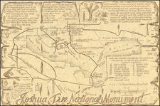
Decorative British Empire Exhibition guide, prepared for the 1924 exhibition at Wembley, in North London.
A pictorial map of the layout of the British Empire Exhibition at Wembley Park in 1924, a swan song for the Empire as it was morphing into the British Commonwealth.
The original Wembley Stadium was built for this event and opened in 1923. The oval is clearly visible, underneath two large areas marked 'Industy' and 'Engineering' and large pavilions for Australia, India and Canada, and smaller ones for other nations, including New Zealand, East Africa, Malay, Burma, Hong Kong and Malta.
Underneath is a diagramatic map of the rail links to Wembley via the lines that are now London Underground, with a circular 'Circle Line' surrounding a silhouette of Nelson's Column against the London skyline.
The mapmaker, Stanley Kennedy North (1887-1942), has drawn upon a number of cartographic influences, including strapwork cartouches reminicent of the first county maps by Christopher Saxton, and the arts and crafts style of the maps of his contempoary, Leslie MacDonald Gill (1884-1947). North later turned to restoring paintings, becoming 'Keeper of the King's Pictures', a semi-formal role later filled by Soviet spy Sir Anthony Blunt.