


|
||

|

|
|

|
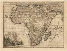
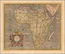
Nice hand-colored example of the most influential maps of Africa published at the end of the 16th century.
Mercator's finely engraved map of Africa depicts the continent as it was known in the late 16th century. This map is based on Gerard Mercator's twenty-one sheet wall map of the world, first published in 1569. The atlas version of the map was engraved by Gerard Mecator's grandson Gerard, in 1595, the year after the elder Gerard Mercator's death. This map has a high degree of accuracy especially along the coastline that was unsurpassed by any other 16th-century cartographer. Much of the interior of Africa defers to the traditions of Ptolemy; the Nile river is shown with two lakes and the Mountains of the Moon across southern Africa. Mercator does show European advance into the interior. For example, Mercator shows Portuguese exploration up the Cuama (Zambezi) River into the interior of south-central Africa in the region of Monomotapa or Benamataxa, as he named it on his map. Ca. Portogal (the Portuguese Fort) is placed on the map within the junction of the Spirito and Cuama rivers.
Mercator tried to adhere to a more scientific approach and did not include the numerous beasts of other cartographers. The only figure within Africa is the seated legendary priest-king, Prester John, in Ethiopia. The cartouche is quite decorative with a bounty of fruit and two satyrs. The fine script is superb and the sea has Mercator's signature moire pattern.
One of the most important geographic enigmas of the Medieval and early modern periods was the kingdom of Prester John. The legend of a Christian Kingdom lost among Muslim lands was popular from the twelfth century and continued long into the seventeenth. Prester John was supposedly descended from one of the three magi. Over time, the utopian kingdom of Prester John came to house a bevy of other fantastical objects, including the Fountain of Youth.
The idea of a Christian King, a Presbyter John, of immense wealth had been circulating since the mid-twelfth century, part of the rumors that swirled around the Crusades. The story received a boost from a mysterious letter sent to the Byzantine Emperor Manuel I. The letter, supposedly written by John, describes his power, faith, and lands. The letter circulated ca. 1165 and survives in nearly 100 medieval manuscript copies. Initially, Europeans thought Prester John’s kingdom was in India, and later in Central Asia. Finally, in the early modern period, the search shifted to Africa, specifically in Christian Ethiopia.
The story and the desire to find the kingdom was ubiquitous across Europe for centuries, losing steam only in the seventeenth century when antiquarians found that the Prester John story had no convincing ties to Ethiopia. Its popularity testifies to the anxieties within the Christian faith during an epoch when Christianity was fighting for survival in the Middle East, and when Christian Europe was often in conflict with Muslims in the Ottoman Empire and was encountering Indigenous peoples, and their religious systems, around the world.
Mountains of the Moon and the source of the Nile
Typically, mapmakers thought the Nile River rose from twin lakes south of the equator, which were near the Mountains of the Moon. Streams from the mountains fed the lakes. Ptolemy describes such a lakes-and -mountains layout in his works, although the precise identification of the Mountains of the Moon may have been a fourth century addition to his text.
Sixteenth century mapmakers, including Waldseemuller, chose to follow the Ptolemaic model. This was typical of cartographers at the time, who had abandoned Ptolemy’s coastlines in favor of the more recent Portuguese outlines yet who also clung to Ptolemaic place names for the interior of Africa well into the nineteenth century.
Giacomo Gastaldi, most likely thanks to sources he read via the travel writer Ramusio, chose to abandon the Mountains of the Moon entirely in his 1564 map of Africa. Instead, he drew a massive central lake from which flows the Nile, Zaire (Congo), Cuama (Zambezi), and Spirito Sancto (Limpopo) Rivers. To the east is another, smaller lake at roughly the same latitude, which also feeds part of the Nile. Therefore, Gastaldi created an entirely different view of the interior of Central Africa, while still embracing Ptolemy’s twin lakes theory.
In Ortelius’ Africa map included in the original 1570 Theatrum, he also included a large central lake, called Cafates. He rejected the name of Zaire-Zembere used by Gastaldi. To the east and just slightly north was another, smaller lake. Rivers from the north of both lakes wend northward and join to form the Nile. The Zaire (Congo) flows from the northeast of Lake Cafates, while the Zuama (Zambezi) exits at the south of the lake. It branches into the Spiritu Sant, or the Limpopo.
In his regional Prester John map, however, Ortelius has brought back the Mountains of the Moon. The Nile still branches from two lakes, but the larger of these is now called Zaire, as it had been with Gastaldi. Clearly Ortelius continued to review sources between drafting the Africa map and the regional map. Mercator and later mapmakers followed mainly in the two-lake model, including iterations of the Mountains of the Moon for centuries.