|
||

|

|
|

|
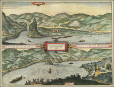
Striking 1844 town plan of Vienna, with vignettes showing ten major churches and buildings.
The map is very detailed, showing the old city surrounded by a fortified gap, with this being encircled by the new city. Detail extends to the north to the Danube.. The Au-Garten is shown, as are many other monuments. Featured above and below the map are vignettes of Stephans-Kirche, the temple in the people's garden, and the Hofftheater, among other important buildings.
This map appeared in Meyer's Grosser Hand-Atlas uber alle Theile der Erde in 170 Karten, an important mid-19th-century German atlas.
Joseph Meyer (1796-1856) was a German publisher who released Meyers Konversations-Lexikon, a German-language encyclopedia in print from 1839 to 1984. Meyer was born in Gotha and educated as a merchant in Frankfurt, an important city in the book trade. He traveled in London in 1816 and was back in German in 1820, where he began to invest in textiles and railways. He opened his publishing operation, Bibliographisches Institut, in 1826. His publications each had a serial number, a new innovation at the time. He was best known for his atlases and the Meyers Universum (1833-1861), which featured steel-engravings of the world. The Universum stretched to 17 volumes in 12 languages and was subscribed to by 80,000 people all over Europe. Thanks to his publishing success, Meyer moved the Institut from Gotha to Hildburghausen in 1828. Meyer died in the latter city in 1856.
![[ Vienna ] Viennense Territorium ob res Bellicas Inter Christianos et Turcas Nuperrime Editum](https://storage.googleapis.com/raremaps/img/small/80253.jpg)
![[ Salzburg Lungau - Tamsweg District -- Road and Trekking Map for Southern Salzburg ]](https://storage.googleapis.com/raremaps/img/small/100458.jpg)