|
||

|

|
|

|
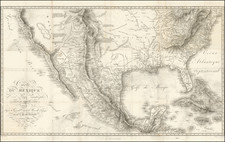
Rare Appearance of the Old Spanish Districts of the Louisiana.
An unusual and very scarce map made to illustrate a French edition of J. Fenimore Cooper's The Prairie and showing five proto-states west of the Mississippi, as well as a very detailed Missouri Territory.
The geopolitical divisions shown on the map are very unusual, and something that we have not been able to find duplicated on any map. West of the Mississippi, it shows, from south to north, Louisiana, Arkansas, Laurence, Girardeau, St. Louis, and Howard; each (except for the top two) extending to present-day Kansas and Oklahoma.
This geography has been called the remnant of the old Spanish and French districts of Louisiana, but this is unlikely for several reasons. Firstly, New Madrid appears to have ruled its own district of the same name when it was first formed. Secondly, Howard, west of St. Louis, likely draws its name from the last pre-statehood governor of Missouri, although this is conjecture.
We have previously seen only one map with a similar division, although it did not name Girardeau County, and did not delineate Arkansas and Louisiana. This was a very rare Spanish map, published in 1834 in Madrid. It is possible that this map draws from that other, or that they both draw from a similar cartographic zeitgeist active in France and Spain at the time.
The map is also interesting for its detailed treatment of the interior of the continent, naming a number of Native American Tribes and giving a detailed treatment to the Rocky Mountains and Plains.
This map was published in Paris in 1835 by Aristide Michel Perrot and engraved by Pierre Tardieu to accompany a French edition of Cooper's work. The map shows the route taken in the story from Cairo westwards along with places of interest.
Pierre Antoine Tardieu (1784-1869), also known to sign his works as PF Tardieu, was a prolific French map engraver and geographer. The Tardieu family, based in Paris, was well known for their talent in engraving, cartography, and illustration. Pierre Antoine’s father, Antoine Francois Tardieu, was an established cartographer who published numerous atlases. His son is said to have collaborated with him for many years before establishing his own independent career.
Pierre Antoine Tardieu’s most famous work includes engravings of the islands of La Palma and Tenerife, for which in 1818 he was awarded a bronze medal by King Louis-Phillipe for the beauty and accuracy of his mapping. Other famous work includes his mapping of Louisiana and Mexico, engravings of Irish counties, maps of Russia and Asia, and his highly celebrated illustrations of all the provinces of France. He was also the first mapmaker to engrave on steel.
Tardieu was a popular map engraver in his lifetime, enjoying the patronage of the likes of Alexander von Humboldt and respect among his peers. In 1837, he was appointed the title Chevalier de la Légion d’honneur. As was written in his obituary in the Bulletin of the Geographical Society of France, he was renowned for his combination of technical talent and scholarly research skills and praised for furthering his family’s well-respected name in the scientific arts.

![[Geology Map of the Texas, California & the Southwest] Esquisse Geologique Des Anciennes Possessions Mexicains Du Nord Incorporees Ala Federation des Etats-Unis . . . 1867](https://storage.googleapis.com/raremaps/img/small/71446.jpg)