|
||

|

|
|

|
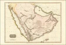
Alain Manesson Mallet's Arabie Moderne, a remarkable miniature map first published in Paris in 1683, provides a fascinating representation of the Arabian Peninsula, the Red Sea, and surrounding areas. Originating from Mallet's prolific Description de l' Univers, this map exhibits the breadth and depth of 17th-century cartography.
Situated in the 17th-century, the map falls within the early modern period of history, a time when European exploratory voyages were expanding knowledge of the world. The Arabian Peninsula, with its rich history and strategic location between Europe, Asia, and Africa, was a subject of intense interest and exploration.
Mallet's Arabie Moderne is a testament to the work that underlies 17th-century cartography. Featured in the ambitious project, Description de l' Univers, the map is a compelling depiction of the Arabian Peninsula and its environs. The map not only depicts the region's geographical intricacies but also underscores the extensive understanding and comprehensive worldview of its time.
Alain Mannesson Mallet (1630-1706) was a French mapmaker and engineer who served in the armies of Louis XIV. After rising through the ranks, Mallet was appointed as Inspector of Fortifications, a job which also required mathematical skills and which made him a competent military engineer. Eventually, he joined the court of Louis XIV at Versailles, where he taught math and focused on writing.
Mallet is best known for his Description de L’Univers, first published in 1683, in five volumes. A wide-ranging geographical work, the Description included textual descriptions of the countries of the world, as well as maps of the celestial sky and the ancient and modern worlds. The Description continued to be published until the early eighteenth century. He also published a work in three volumes on warfare (1684) and a primer on geometry (1702).
![[ Medina, Saudi Arabia ] Medine](https://storage.googleapis.com/raremaps/img/small/97808.jpg)
![[ Turkish Empire ] Turcicum Imperium. Turckiche Reich. Concordia res parvae crescunt Discordia maximae dilabuntur](https://storage.googleapis.com/raremaps/img/small/68352.jpg)