|
||

|

|
|

|
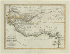
Fascinating Italian map of the Congo Free State and its surroundings, produced by Montuori Francesco between 1898 and 1908.
The map provides an unusually good rendition of the internal boundaries and communities of the Congo Free State during the latter half of Leopold II's infamous ownership of the country as his personal fief.
The map is ascribed to Lieutenant Francesco Montuori. Lamentably, we have been unable to locate any further information on him. Working backward, his role as a lieutenant may suggest some military implication for the map, perhaps related to Italian aspirations in Africa, though that is very speculative.
Dating the Map
The map lists several post-Berlin Conference European colonial possessions, dating the map to at least 1885 or later.
The internal provinces of the Congo Free State accord closely with its divisions in 1895, except for the "Districts de la Province Orientale," which was created in 1898.
The Congo Free State became the Belgian Congo after Leopold II's death in 1909, establishing the end date after which the map would not have been published in this configuration.
Furthermore, the Lado Enclave is shown in the northeast of the map; this ceased existence in 1910.
Rarity
The map is evidently extremely rare. We have been unable to locate any other examples with OCLC or general internet searches.

![[Senegal / Safaris / Railroads] Chemins de Fer du Senegal](https://storage.googleapis.com/raremaps/img/small/88789.jpg)