|
||

|

|
|

|
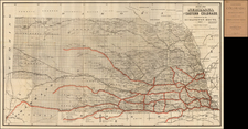
Very rare, apparently separately issued map produced for the Indian Campaigns of the mid-1870s.
The map shows central Nebraska in extremely fine detail, centered on the Platte River between Kearney and Columbus. Rivers, hydrographic details roads, and railroads are all shown. The Pawnee Reservation is shown and delimited near Columbus. Northwards, the map extends as far as the Missouri River.
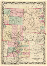
The map was drawn by Jones based on his explorations from 1871 to 1873 of Wyoming and the Uinta Mountains. Also in 1874, Jones produced a report that advocated for the construction of a military wagon road from Green River City to Yellowstone, and to Fort Ellis. This was presented to the House of Representatives as part of H. R. 2854.
Rarity
This appears to be the first time that we have seen the map on the market. We locate four institutional examples of the map, including the University Michel de Montaigne Bordeaux, Rutherford B Hayes Presidential Center, NYPL, and Rumsey.