|
||

|

|
|

|
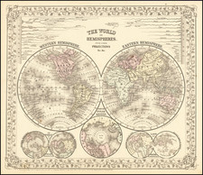
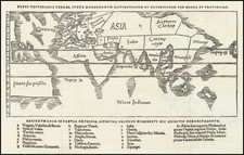
Striking Mid-Eighteenth-Century Hemispheric Maps
Fine examples of the 1745 state of De L'Isle's maps of the Western and Eastern Hemispheres.
Originally prepared by Guillaume De L’Isle in 1720, and printed in 1724, they were re-released by his son-in-law, Philippe Buache. While Buache updated later states, this 1745 state remains true to the first state and only adds his imprimatur.
The Western Hemisphere and the persistence of geographic myths
When originally issued, the western hemisphere included one of the earliest peninsular projections of California after Kino, in a configuration which became a standard for other mapmakers throughout the century.
While California is no longer an island, other quasi-myths remain. For example, Hudson’s Bay is open-ended to the west, suggesting a possible Northwest Passage. In the Atlantic, an inscription reads, “Isle de Bus cidevant Frisland.” This refers to two chimeric islands, Bus and Frisland (see below). To the southeast is the Roche de Bresil, another changeable feature (see below). In the North Pacific, a coastline meanders from the western edge of the hemisphere; this is De Gama Land, yet another specious landmass that supposedly stretched to the size of a continent (see below).
Near the Californian coast is Quivira, which refers to the Seven Cities of Gold sought by the Spanish explorer Francisco Vasquez de Coronado in 1541. In 1539, Coronado wandered over what today is Arizona and New Mexico, eventually heading to what is now Kansas to find the supposedly rich city of Quivira. Although he never found the cities or the gold, the name stuck on maps of southwest North America, wandering from east to west.
All of these places that are now understood as mythical were still up for debate in the eighteenth-century. De L’Isle was one of the most discerning geographers of his day, so their inclusion here underlines just how conjectural map compilation was. The map remains an excellent example of cartographic practice from one of the leading practitioners of the period.
The Eastern Hemisphere and Dutch encounters with Australia
De Gama land and the associated Compagnie’s Land and Staten Land are both to the north of Japan. They are also east of a curious peninsula on the mainland, Terre D’Eso ou D’Yeco. This is Yesso, which refers to Hokkaido. Often shown as an over-large island, here it is shown as part of Asia, a rare configuration for the feature (see below). The extension of Yesso to the east also creates space for the Sea of Korea seen here.
The South Pole on both hemispheres is left empty, although they are labelled as the Terres Australes ou Antarctiques, or the Antarctic or Austral lands.
The major feature of interest in this hemisphere is the unfinished outline of Nouvelle Hollande, or New Holland (Australia). It nearly extends to New Guinea and is populated with mainly Dutch toponyms. Whereas the Portuguese were the first Europeans to tap the lucrative resources of the East Indies, other European powers quickly joined the race. The Dutch East India Company (VOC), founded in 1602, was based in Amsterdam with a local headquarters in Batavia (Jakarta). Dutch ships roved the waters of the Indian Ocean. A few crossed the sea at southern latitudes, taking advantage of the winds of the roaring forties, which put them on a collision course with the continent of Australia, then still unknown to Europeans.
These ships were following the Brouwer Route to Jakarta, so-called because it was explored in 1611 by Hendrick Brouwer. Less than five years later, it was named the prescribed route from the Cape of Good Hope to Java and following the route became compulsory for all VOC ships, unless they were destined directly for China and Ceylon, rather than Batavia. Ships were supposed to turn north when they sighted Amsterdam Island or St. Paul Island, both of which are included here. However, the methods for calculating longitude in the seventeenth century were imprecise and some ships continued east, eventually running afoul of the Australian coast.
The first of these to contact West Australia was the Eendracht in 1616, which was blown off course en route to the East Indies. It was commanded by Dirk Hartog and Hartog’s landing was the first recorded European landing on the western coast of Australia. It is marked here with Terre d’Endracht de la Concorde. The crew commemorated their discovery by erecting a post with a pewter dish inscribed with their ship’s information—the earliest physical record that historians have of any European landing in Australia.
Only three years later, Jacob d’Edel, in the Amsterdam, along with Frederik de Houtman, in the Dordrecht, came within sight of the western coast. The Abrolhos d’Houtman are an archipelago named for the navigator who sighted them, or at least it was Houtman who reported the islands to the VOC. The islands became infamous after the Batavia shipwrecked there in 1627. The mutiny and massacre that became Batavia’s fate fascinated all of Europe, but also flagged the islands as treacherous for ships, which is why they deserve such attention on charts
Other voyages also sighted or landed in Western Australia in the 1620s. This map references that of Gerrit Fredericsz De Wit (here Vit) in 1628, of the Leeuwin (here Leuwin) in 1622, and of Pieter Nuyts, who commanded the Gulde Zeepaert along the southern coast in 1627.
By the 1640s, the officials of the VOC were eager to know the extent of the south lands and if they included any useful resources or willing trading partners. They appointed Abel Tasman to pursue these questions. Tasman's 1642-43 voyage was the first to circumnavigate the whole of the Australasia region, thus proving it was a separate entity unconnected from a mythical, and massive, southern continent. He surveyed the south coast of Tasmania, which he called Van Diemens Land (here Terre de Diemen) after the VOC governor of Batavia, and the western coast of New Zealand, as well as the Tonga and Fiji Archipelagos. While important for geography, his voyage was nevertheless a disappointment to the VOC, as it netted no new commercial opportunities. This first voyage is shown here with toponyms and the ship’s track.
Tasman’s second voyage proved even less successful. He was supposed to find a passage south of New Guinea to the east coast of Australia, but he missed the strait and instead thought it a bay. He did, however, more fully chart Australia’s northern coastline, which had only been sporadically encountered to that point. Previously, information for the north coast, especially for portions of the coasts in what it today Queensland, Australia, come from the voyage of the Dutch vessel Duyfken in 1605-06. Under the command of Willem Janszoon, the Duyfken explored the eastern shore of the Gulf of Carpentaria, just below the Cape York Peninsula, a venture which was famously the first recorded European contact with Australia.
Map as history of exploration
The map can also act as a good overview of the history of maritime exploration to the early-eighteenth century. It includes the tracks of important voyages, including:
- Ferdinand Magellan commanded what became the first known circumnavigation of the world (1519-1522), although he died in the Philippines.
- Juan Gaetano (here Gaetan) crossed the Pacific from east to west in 1542.
- Alvaro de Mendaña led a Spanish expedition to the Solomon Islands in 1567-9, but his crew forced his return to Peru. Another attempt was made from 1595-6 to return to the Solomons, but they had not been charted accurately. Mendaña died on Santa Cruz, leaving his wife in charge of the settlement they had started. She decided to return to Spanish dominions and they arrived in the Philippines in early 1596.
- Pedro Fernandez de Quiros accompanied Mendaña on his second voyage and was a skilled pilot. After returning to Spain, he convinced authorities that he could find Terra Australis, the southern continent, if they gave him ships and supplies. He set out in 1605 and eventually landed on what is today Vanuatu. He mistook one of the islands for the fabled continent and called is Austrialia de Espiritu Santo (here Terre Australe du St Esprit). Quiros intended to set up a colony, but his crew forced him to leave.
- Jacques Le Maire, along with Willem Schouten, circumnavigated via Cape Horn in 1615-1617, the first to sail round South America instead of through the Straits of Magellan.
- As explained above, Abel Tasman’s first expedition (1642-4) is shown here, the first to contact New Zealand.
- Edmond Halley commanded two South Atlantic expeditions in the late-seventeenth century to study magnetic declination. He also famously described icebergs, which are included on this map.
- The St. Louis, in 1708, was a French merchant enterprise. It was the first ship to cross from Cape Horn to the Cape of Good Hope.
- The St. Antoine was a French merchant vessel, the first non-Spanish voyage across the Pacific from west to east. The ship, commanded by Nicolas de Frondant, traded with Chile and Peru in 1709.
This is an aesthetically-pleasing and geographically intriguing world map tied to two of the century’s most important mapmakers. It would make an important addition to any collection of world maps or early modern works.
North Pacific chimeras: Yesso, De Gama, and Compagnie Land
The etymology of the idiom Yesso (Eso, Yeco, Jesso, Yedso) is most likely the Japanese Ezo-chi; a term used for the lands north of the island of Honshu. During the Edō period (1600-1886), it came to represent the ‘foreigners’ on the Kuril and Sakhalin islands. As European traders came into contact with the Japanese in the seventeenth century, the term was transferred onto European maps, where it was often associated with the island of Hokkaido. It varies on maps from a small island to a near-continent sized mass that stretches from Asia to Alaska.
The toponym held interest for Europeans because the island was supposedly tied to mythic riches. Father Francis Xavier (1506-1552), an early Jesuit missionary to Japan and China, related stories that immense silver mines were to be found on a secluded Japanese island; these stories were echoed in Spanish reports. The rumors became so tenacious and tantalizing that Abraham Ortelius included an island of silver north of Japan on his 1589 map of the Pacific.
Yesso is often tied to two other mythical North Pacific lands, Gamaland and Compagnies Land. Juan de Gama, the grandson of Vasco de Gama, was a Portuguese navigator who was accused of illegal trading with the Spanish in the East Indies. Gama fled and sailed from Macau to Japan in the later sixteenth century. He then struck out east, across the Pacific, and supposedly saw lands in the North Pacific. These lands were initially shown as small islands on Portuguese charts, but ballooned into a continent-sized landmass in later representations.
Several voyagers sought out these chimerical islands, including the Dutchmen Matthijs Hendrickszoon Quast in 1639 and Maarten Gerritszoon Vries in 1643. Compagnies Land, often shown along with Staten Land, were islands sighted by Vries on his 1643 voyage. He named the islands for the Dutch States General (Staten Land) and for the Dutch East India Company (VOC) (Compagnies, or Company’s Land). In reality, he had re-discovered two of the Kuril Islands. However, other mapmakers latched onto Compagnies Land in particular, enlarging and merging it with Yesso and/or Gamaland.
In the mid-eighteenth century, Vitus Bering, a Danish explorer in Russian employ, and later James Cook would both check the area and find nothing. La Perouse also sought the huge islands, but found only the Kurils, putting to rest the myth of the continent-sized dream lands.
Mythical islands of the North Atlantic
The North Atlantic is especially prone to mythical or elusive islands, a result of the rich seafaring cultures that border it and the intensity of the expansion and commercial trade of European empires in the Atlantic World.
Perhaps the most famous of the Atlantic mythical islands is Frisland, near Iceland, whose fascinating story and association with the Zeno Map is told elsewhere. Nearby to Frisland on many maps is Buss Island. This island originates in reports about Martin Frobisher’s third voyage, specifically George Best’s A True Discourse of the Late Voyages of Discoverie of a Passage to Cathaya (1578). One of Frobisher’s ships, the Emmanuel, which was a busse, hence the island’s name, supposedly sailed along the island on its homeward journey in 1578. Hakluyt included a description of the island in his Principal Navigations (1598). It was variably sighted and sought by seventeenth-century navigators and John Seller charted it his English Pilot (1671). The Hudson’s Bay Company (HBC) sent an expedition in search of it in 1675, but they found nothing. By the eighteenth-century, cartographers supposed the island was fabulous or sunken, demoting it to a navigational hazard. A further voyage in 1791 finally proved its non-existence.
Hy Brasil is an enduring Atlantic chimera emerging from Celtic folklore. It ranges on maps from just off the west coast of Ireland to the area around the Azores. The island was initially described as a rich paradise not unlike Atlantis; it emerged from the depths for a short period and then would disappear. It started to appear on portolan charts in the fourteenth century and continued to be a stalwart of maps and charts into the nineteenth century. The island was the subject of a fanciful pamphlet by Richard Head in 1675. Despite no accurate reports of its whereabouts, the island appeared on Admiralty charts and other reputable maps for centuries, usually in the latitude of 51°N and at a longitude of 17°W.
A final island of note is that of St. Brendan. Like Hy Brasil, this island is also connected to Irish lore. St. Brendan, hearing of a promised land from St. Barrind, decided to take a group of monks to find the paradise in the sixth century. After 43 days the monks landed on a deserted island. This is only the first of a series of islands which they encounter, before facing a frozen sea. They have more adventures and eventually return home. The island itself initially appeared near the Canary Islands, but by 1570 Abraham Ortelius placed it near Newfoundland, where it stayed until slowly disappearing from maps in the seventeenth century.
Guillaume De L'Isle (1675-1726) is probably the greatest figure in French cartography. Having learned geography from his father Claude, by the age of eight or nine he could draw maps to demonstrate ancient history. He studied mathematics and astronomy under Cassini, from whom he received a superb grounding in scientific cartography—the hallmark of his work. His first atlas was published in ca. 1700. In 1702 he was elected a member of the Academie Royale des Sciences and in 1718 he became Premier Geographe du Roi.
De L'Isle's work was important as marking a transition from the maps of the Dutch school, which were highly decorative and artistically-orientated, to a more scientific approach. He reduced the importance given to the decorative elements in maps, and emphasized the scientific base on which they were constructed. His maps of the newly explored parts of the world reflect the most up-to-date information available and did not contain fanciful detail in the absence of solid information. It can be fairly said that he was truly the father of the modern school of cartography at the commercial level.
De L’Isle also played a prominent part in the recalculation of latitude and longitude, based on the most recent celestial observations. His major contribution was in collating and incorporating this latitudinal and longitudinal information in his maps, setting a new standard of accuracy, quickly followed by many of his contemporaries. Guillaume De L’Isle’s work was widely copied by other mapmakers of the period, including Chatelain, Covens & Mortier, and Albrizzi.
Philippe Buache (1700-1773) was one of the most famous French geographers of the eighteenth century. Buache was married to the daughter of the eminent Guillaume Delisle and worked with his father-in-law, carrying on the business after Guillaume died. Buache gained the title geographe du roi in 1729 and was elected to the Academie des Sciences in the same year. Buache was a pioneering theoretical geographer, especially as regards contour lines and watersheds. He is best known for his works such as Considérations géographiques et physiques sur les découvertes nouvelles dans la grande mer (Paris, 1754).
![[ World Atlas ] [ Composite Atlas of the World including important American maps and Whiston's Scheme of the Solar System ]](https://storage.googleapis.com/raremaps/img/small/100165.jpg)