This item has been sold, but you can enter your email address to be notified if another example becomes available.


|
||

|

|
|

|
Stock# 85816
Description
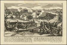
An excellent early map of the region bounded by New England, Lake Ontario and the northern Chesapeake River, centered on New York and Connecticut from a Dutch edition of Bellin's Histoire Generale des Voyages.
Shows towns, roads, mountains, rivers, islands, capes, ports and other nice details. A nice French & Indian War map of the Northern British Colonies.
![[Last of the Mohicans / New York] Carte dressee pour la lecture du Dernier des Mohicans Roman de J. Fenimore Cooper](https://storage.googleapis.com/raremaps/img/small/86045.jpg)