|
||

|

|
|

|
Focal Point of the West - All Factors Favorable
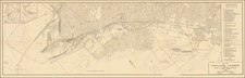
Great, scarce map of the East Bay, showing the division between residential, industrial, and agricultural areas at the tip of the San Francisco metropolis. Published at the end of the Second World War, in 1945, when the transformation of California into its modern heavyweight status was well-underway, this map is representative of the developmental ambitions that made the Bay Area what it is today. The map was printed locally, in Richmond, by the Independent Printing Company.
The map shows Contra Costa County in bright colors, with San Francisco and Oakland in more muted tones. Commercial areas, including Richmond, Walnut Creek, Martinez, and Antioch are shown in yellow. Existing industrial areas appear in dark red, while the ones available for development are a lighter red. A similar distinction is made for agricultural areas.
The vision of the map is littered with further advertisements for Contra Costa County (advantageous freight rates!), but most impressive is the data visualization in the upper right showing the exponential growth of the county. Showing the growth since 1950 and comparing the population to the Bay Area, California, and the US as a whole, Contra Costa is shown as a smiling giant, the envy of the rest of the country.
This map was published by the Contra Costa County Development Association in partnership with L. Cedric Macabee, an engineering consultant with offices in Palo Alto and Martinez. Macabee is known to have worked on various city projects including the possible development of a canal in Sacramento County and the Palo Alto sewage system.
Rarity
OCLC lists only three examples, at Berkley, LOC (dated to 1950s), and UCSB.
![[ Hayward and San Leandro ] Residence & Architectural Works of Henry Mininger Mt. Eden, Residence and Farm of O. Dennis, & Residence and Farm of F. Hauschildt, Eden Tt., Alameda County, California](https://storage.googleapis.com/raremaps/img/small/102041.jpg)

![(Bird's-Eye View of California) San Francisco Invites You [cover title]](https://storage.googleapis.com/raremaps/img/small/92552.jpg)