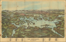
|
||

|

|
|

|
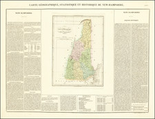
Fine pictorial map of New Hampshire by Elizabeth Shurtleff and Helen F. McMillin. The decorative border of this map is filled with the seals of various New Hampshire cities and schools (Phillips Exter, Holderness, University of New Hampshire, St. Paul's, and Dartmouth) as well as the state seals of 1776 and 1784. The map itself is filled with illustrated historical details, references to local jokes/stories, and mainly shows illustrated figures doing various activities, often with comical captions.
The sneezing man in Bethlehem reference's the resort town's fame as one free of Hay Fever. Tapped Maple trees are pictured near Rumney and Acworth. Shakers are shown near Enfield. Dancers are shown near Peterborough, presumably because of the now-defunct Mariarden Theater. Brigham Young is pictured near Peterborough. A man is planting an "Indian Stream Republic" flag in the northwest corner. At Phillips Exter, "Plupy", the subject of stories that author and alum Henry Shute based on his boyhood, talks to Tom Bailey in Portsmouth, the protagonist of Tom Bailey Aldrich's semi-autobiographical The Story of a Bad Boy. In Tilton, Daniel Webster walks along the former "Merrimack Valley Road," renamed the Daniel Webster Highway in 1925.
The influence of MacDonald Gill's Wonderground map of London Town is apparent in the "speech bubbles" with short, pithy sayings or quips emerging from the mouths of many of the characters.