This item has been sold, but you can enter your email address to be notified if another example becomes available.


|
||

|

|
|

|
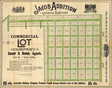
Stock# 85732
Description
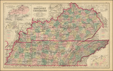
Detailed and interesting map of Kentucky, published by H.S. Tanner, published before the establishment of Fulton County.
The map is hand-colored by county and shows towns, rivers, lakes, railroads, roads, distances, forts, etc.
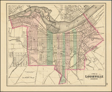
Tables of steamboat routes and distances. Large insets of area around Lexington, the Washington and Clarksburg area, and the Falls of Ohio, showing Jeffersonville, Louisville, Shippingport, Portland, and the Louisville and Portland Canal bypassing the falls.
Condition Description
Original hand-color by county. Minor foxing.