This item has been sold, but you can enter your email address to be notified if another example becomes available.


|
||

|

|
|

|
Stock# 85656
Description
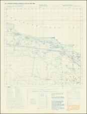
Interesting World War II map of the El Hammam, on the western edge of the Nile Delta near El Alamein. This map was based on Survey of Egypt information and printed by the 512 Forward Survey in June of 1942, two months before the start of the Second Battle of El Alamein.
The map shows an area some fifty kilometers wide along the Mediterranean coastline which would have been an important way station between Alexandria and the frontlines in western Egypt. The main east-west train line is featured here, as are minor towns including El Hammam and Borg El-Arab city.
The map includes a legend in English and in Arabic and various instructions for the officers and soldiers meant to use the map.
Condition Description
Fold toning. Minor soiling.
![(World War II) [Iwo Jima Aerial Reconnaissance Photograph, March 8, 1945]](https://storage.googleapis.com/raremaps/img/small/83776.jpg)